You are here: Home > Network List > TA - USArray Transportable Network (new EarthScope stations) Stations List
> Station J01E Myrtle Point, OR, USA > Earthquake Result Viewer
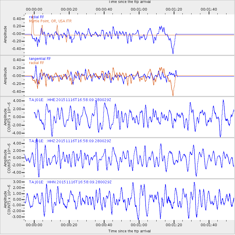
J01E Myrtle Point, OR, USA - Earthquake Result Viewer
*The percent match for this event was below the threshold and hence no stack was calculated.
| Earthquake location: |
Kuril Islands |
| Earthquake latitude/longitude: |
48.3/154.3 |
| Earthquake time(UTC): |
2015/11/16 (320) 16:49:15 GMT |
| Earthquake Depth: |
42 km |
| Earthquake Magnitude: |
5.8 MWB |
| Earthquake Catalog/Contributor: |
NEIC PDE/NEIC COMCAT |
|
| Network: |
TA USArray Transportable Network (new EarthScope stations) |
| Station: |
J01E Myrtle Point, OR, USA |
| Lat/Lon: |
43.16 N/123.93 W |
| Elevation: |
128 m |
|
| Distance: |
54.8 deg |
| Az: |
62.469 deg |
| Baz: |
305.976 deg |
| Ray Param: |
$rayparam |
*The percent match for this event was below the threshold and hence was not used in the summary stack. |
|
| Radial Match: |
43.274406 % |
| Radial Bump: |
400 |
| Transverse Match: |
45.98941 % |
| Transverse Bump: |
400 |
| SOD ConfigId: |
7422571 |
| Insert Time: |
2019-04-21 09:36:34.788 +0000 |
| GWidth: |
2.5 |
| Max Bumps: |
400 |
| Tol: |
0.001 |
|
Signal To Noise
| Channel | StoN | STA | LTA |
| TA:J01E: :HHZ:20151116T16:58:09.280029Z | 1.971976 | 2.7890485E-6 | 1.414342E-6 |
| TA:J01E: :HHN:20151116T16:58:09.280029Z | 0.49718043 | 6.917468E-7 | 1.3913394E-6 |
| TA:J01E: :HHE:20151116T16:58:09.280029Z | 1.1147426 | 1.8887491E-6 | 1.6943366E-6 |
| Arrivals |
| Ps | |
| PpPs | |
| PsPs/PpSs | |


