You are here: Home > Network List > TA - USArray Transportable Network (new EarthScope stations) Stations List
> Station J26L Joseph Creek, AK, USA > Earthquake Result Viewer
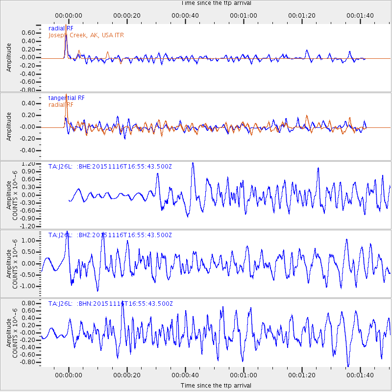
J26L Joseph Creek, AK, USA - Earthquake Result Viewer
*The percent match for this event was below the threshold and hence no stack was calculated.
| Earthquake location: |
Kuril Islands |
| Earthquake latitude/longitude: |
48.3/154.3 |
| Earthquake time(UTC): |
2015/11/16 (320) 16:49:15 GMT |
| Earthquake Depth: |
42 km |
| Earthquake Magnitude: |
5.8 MWB |
| Earthquake Catalog/Contributor: |
NEIC PDE/NEIC COMCAT |
|
| Network: |
TA USArray Transportable Network (new EarthScope stations) |
| Station: |
J26L Joseph Creek, AK, USA |
| Lat/Lon: |
64.50 N/143.56 W |
| Elevation: |
1144 m |
|
| Distance: |
36.3 deg |
| Az: |
40.288 deg |
| Baz: |
273.99 deg |
| Ray Param: |
$rayparam |
*The percent match for this event was below the threshold and hence was not used in the summary stack. |
|
| Radial Match: |
60.385643 % |
| Radial Bump: |
400 |
| Transverse Match: |
53.325783 % |
| Transverse Bump: |
400 |
| SOD ConfigId: |
7422571 |
| Insert Time: |
2019-04-21 09:36:39.100 +0000 |
| GWidth: |
2.5 |
| Max Bumps: |
400 |
| Tol: |
0.001 |
|
Signal To Noise
| Channel | StoN | STA | LTA |
| TA:J26L: :BHZ:20151116T16:55:43.500Z | 2.7515397 | 6.606942E-7 | 2.40118E-7 |
| TA:J26L: :BHN:20151116T16:55:43.500Z | 1.3175896 | 2.1896216E-7 | 1.6618388E-7 |
| TA:J26L: :BHE:20151116T16:55:43.500Z | 3.9680266 | 4.0269722E-7 | 1.0148552E-7 |
| Arrivals |
| Ps | |
| PpPs | |
| PsPs/PpSs | |


