You are here: Home > Network List > TA - USArray Transportable Network (new EarthScope stations) Stations List
> Station L04D Klamath Falls, OR, USA > Earthquake Result Viewer
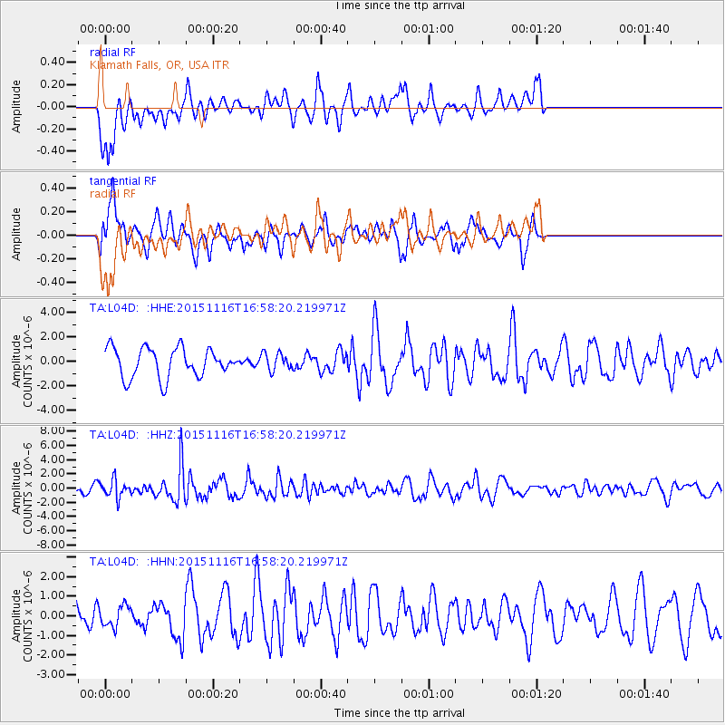
L04D Klamath Falls, OR, USA - Earthquake Result Viewer
*The percent match for this event was below the threshold and hence no stack was calculated.
| Earthquake location: |
Kuril Islands |
| Earthquake latitude/longitude: |
48.3/154.3 |
| Earthquake time(UTC): |
2015/11/16 (320) 16:49:15 GMT |
| Earthquake Depth: |
42 km |
| Earthquake Magnitude: |
5.8 MWB |
| Earthquake Catalog/Contributor: |
NEIC PDE/NEIC COMCAT |
|
| Network: |
TA USArray Transportable Network (new EarthScope stations) |
| Station: |
L04D Klamath Falls, OR, USA |
| Lat/Lon: |
42.22 N/122.30 W |
| Elevation: |
1437 m |
|
| Distance: |
56.3 deg |
| Az: |
62.522 deg |
| Baz: |
307.105 deg |
| Ray Param: |
$rayparam |
*The percent match for this event was below the threshold and hence was not used in the summary stack. |
|
| Radial Match: |
69.71697 % |
| Radial Bump: |
400 |
| Transverse Match: |
60.959644 % |
| Transverse Bump: |
400 |
| SOD ConfigId: |
7422571 |
| Insert Time: |
2019-04-21 09:36:42.793 +0000 |
| GWidth: |
2.5 |
| Max Bumps: |
400 |
| Tol: |
0.001 |
|
Signal To Noise
| Channel | StoN | STA | LTA |
| TA:L04D: :HHZ:20151116T16:58:20.219971Z | 1.5258086 | 1.1806086E-6 | 7.737593E-7 |
| TA:L04D: :HHN:20151116T16:58:20.219971Z | 0.6107753 | 5.2673596E-7 | 8.6240544E-7 |
| TA:L04D: :HHE:20151116T16:58:20.219971Z | 0.5477666 | 6.3536083E-7 | 1.1599116E-6 |
| Arrivals |
| Ps | |
| PpPs | |
| PsPs/PpSs | |


