You are here: Home > Network List > TA - USArray Transportable Network (new EarthScope stations) Stations List
> Station M54A Oil Creek State Park, Oil City, PA, USA > Earthquake Result Viewer
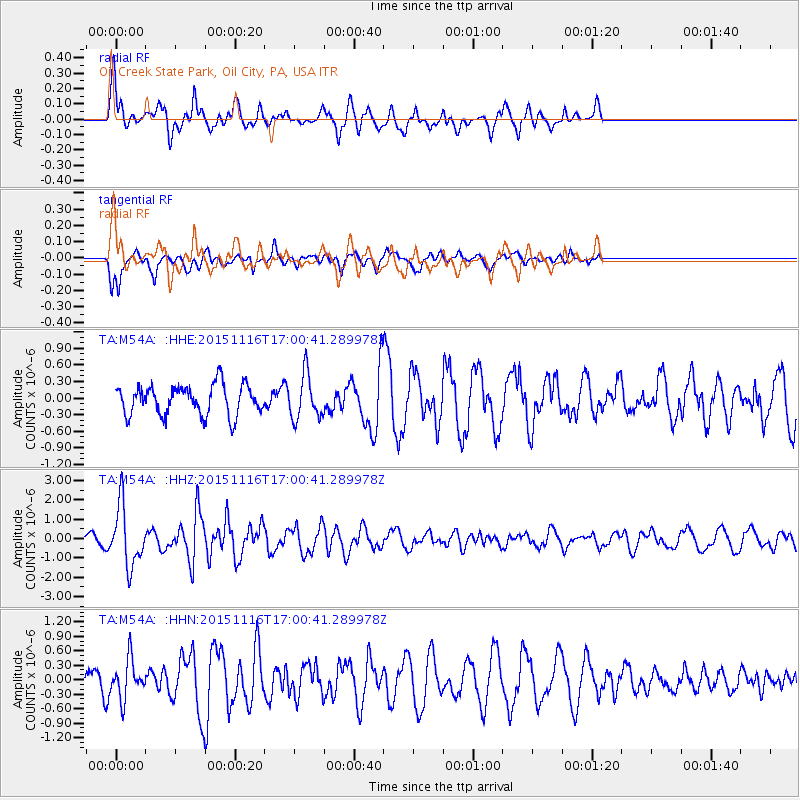
M54A Oil Creek State Park, Oil City, PA, USA - Earthquake Result Viewer
*The percent match for this event was below the threshold and hence no stack was calculated.
| Earthquake location: |
Kuril Islands |
| Earthquake latitude/longitude: |
48.3/154.3 |
| Earthquake time(UTC): |
2015/11/16 (320) 16:49:15 GMT |
| Earthquake Depth: |
42 km |
| Earthquake Magnitude: |
5.8 MWB |
| Earthquake Catalog/Contributor: |
NEIC PDE/NEIC COMCAT |
|
| Network: |
TA USArray Transportable Network (new EarthScope stations) |
| Station: |
M54A Oil Creek State Park, Oil City, PA, USA |
| Lat/Lon: |
41.51 N/79.66 W |
| Elevation: |
488 m |
|
| Distance: |
78.7 deg |
| Az: |
38.251 deg |
| Baz: |
326.603 deg |
| Ray Param: |
$rayparam |
*The percent match for this event was below the threshold and hence was not used in the summary stack. |
|
| Radial Match: |
76.43302 % |
| Radial Bump: |
400 |
| Transverse Match: |
77.94226 % |
| Transverse Bump: |
373 |
| SOD ConfigId: |
7422571 |
| Insert Time: |
2019-04-21 09:36:51.793 +0000 |
| GWidth: |
2.5 |
| Max Bumps: |
400 |
| Tol: |
0.001 |
|
Signal To Noise
| Channel | StoN | STA | LTA |
| TA:M54A: :HHZ:20151116T17:00:41.289978Z | 3.927247 | 1.5357989E-6 | 3.9106246E-7 |
| TA:M54A: :HHN:20151116T17:00:41.289978Z | 2.1920447 | 4.0107471E-7 | 1.8296831E-7 |
| TA:M54A: :HHE:20151116T17:00:41.289978Z | 1.4737595 | 3.9496183E-7 | 2.679961E-7 |
| Arrivals |
| Ps | |
| PpPs | |
| PsPs/PpSs | |


