You are here: Home > Network List > TA - USArray Transportable Network (new EarthScope stations) Stations List
> Station MDND Maddock, ND, USA > Earthquake Result Viewer
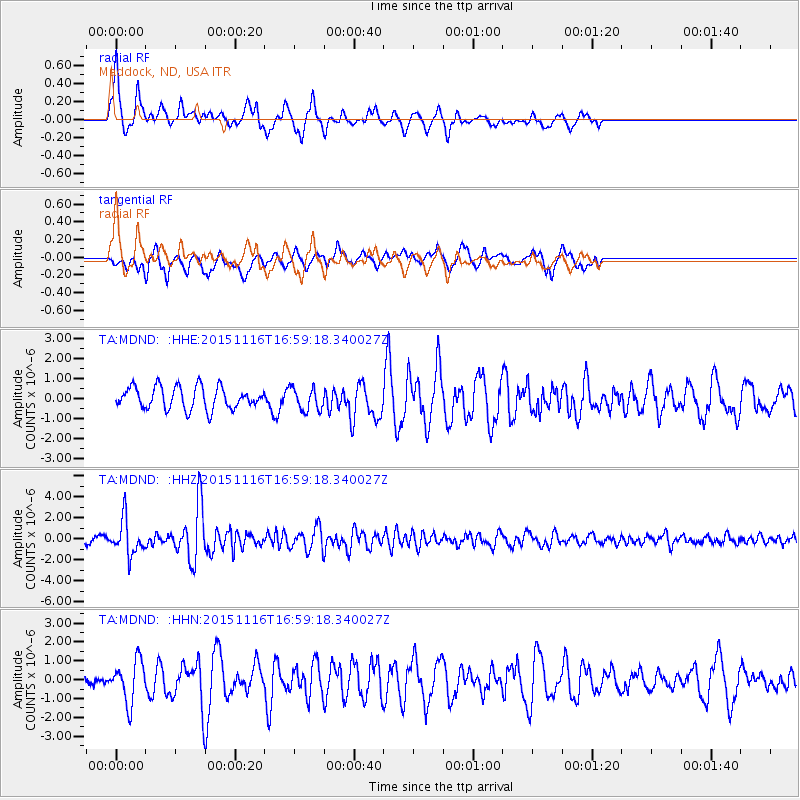
MDND Maddock, ND, USA - Earthquake Result Viewer
*The percent match for this event was below the threshold and hence no stack was calculated.
| Earthquake location: |
Kuril Islands |
| Earthquake latitude/longitude: |
48.3/154.3 |
| Earthquake time(UTC): |
2015/11/16 (320) 16:49:15 GMT |
| Earthquake Depth: |
42 km |
| Earthquake Magnitude: |
5.8 MWB |
| Earthquake Catalog/Contributor: |
NEIC PDE/NEIC COMCAT |
|
| Network: |
TA USArray Transportable Network (new EarthScope stations) |
| Station: |
MDND Maddock, ND, USA |
| Lat/Lon: |
47.85 N/99.60 W |
| Elevation: |
479 m |
|
| Distance: |
64.8 deg |
| Az: |
45.634 deg |
| Baz: |
314.868 deg |
| Ray Param: |
$rayparam |
*The percent match for this event was below the threshold and hence was not used in the summary stack. |
|
| Radial Match: |
78.1986 % |
| Radial Bump: |
341 |
| Transverse Match: |
56.93185 % |
| Transverse Bump: |
400 |
| SOD ConfigId: |
7422571 |
| Insert Time: |
2019-04-21 09:36:52.626 +0000 |
| GWidth: |
2.5 |
| Max Bumps: |
400 |
| Tol: |
0.001 |
|
Signal To Noise
| Channel | StoN | STA | LTA |
| TA:MDND: :HHZ:20151116T16:59:18.340027Z | 6.5016227 | 1.6702379E-6 | 2.5689556E-7 |
| TA:MDND: :HHN:20151116T16:59:18.340027Z | 2.1893394 | 1.1068147E-6 | 5.055473E-7 |
| TA:MDND: :HHE:20151116T16:59:18.340027Z | 0.98325294 | 5.372229E-7 | 5.4637303E-7 |
| Arrivals |
| Ps | |
| PpPs | |
| PsPs/PpSs | |


