You are here: Home > Network List > TA - USArray Transportable Network (new EarthScope stations) Stations List
> Station N31M Braeburn, Yukon, CA > Earthquake Result Viewer
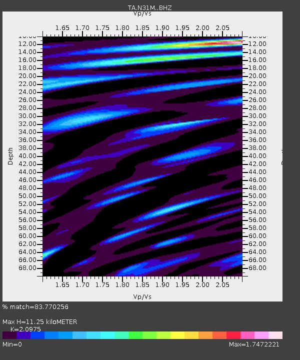
N31M Braeburn, Yukon, CA - Earthquake Result Viewer
| Earthquake location: |
Kuril Islands |
| Earthquake latitude/longitude: |
48.3/154.3 |
| Earthquake time(UTC): |
2015/11/16 (320) 16:49:15 GMT |
| Earthquake Depth: |
42 km |
| Earthquake Magnitude: |
5.8 MWB |
| Earthquake Catalog/Contributor: |
NEIC PDE/NEIC COMCAT |
|
| Network: |
TA USArray Transportable Network (new EarthScope stations) |
| Station: |
N31M Braeburn, Yukon, CA |
| Lat/Lon: |
61.49 N/135.78 W |
| Elevation: |
716 m |
|
| Distance: |
40.3 deg |
| Az: |
44.206 deg |
| Baz: |
283.998 deg |
| Ray Param: |
0.074399345 |
| Estimated Moho Depth: |
11.25 km |
| Estimated Crust Vp/Vs: |
2.10 |
| Assumed Crust Vp: |
6.419 km/s |
| Estimated Crust Vs: |
3.06 km/s |
| Estimated Crust Poisson's Ratio: |
0.35 |
|
| Radial Match: |
83.770256 % |
| Radial Bump: |
400 |
| Transverse Match: |
66.765305 % |
| Transverse Bump: |
400 |
| SOD ConfigId: |
7422571 |
| Insert Time: |
2019-04-21 09:36:55.785 +0000 |
| GWidth: |
2.5 |
| Max Bumps: |
400 |
| Tol: |
0.001 |
|

Signal To Noise
| Channel | StoN | STA | LTA |
| TA:N31M: :BHZ:20151116T16:56:16.950012Z | 9.036586 | 2.3879877E-6 | 2.6425775E-7 |
| TA:N31M: :BHN:20151116T16:56:16.950012Z | 2.5575309 | 8.628758E-7 | 3.373863E-7 |
| TA:N31M: :BHE:20151116T16:56:16.950012Z | 5.1821404 | 1.5830173E-6 | 3.0547557E-7 |
| Arrivals |
| Ps | 2.0 SECOND |
| PpPs | 5.1 SECOND |
| PsPs/PpSs | 7.2 SECOND |


