You are here: Home > Network List > TA - USArray Transportable Network (new EarthScope stations) Stations List
> Station N54A Moraine State Park, Portersville, PA, USA > Earthquake Result Viewer
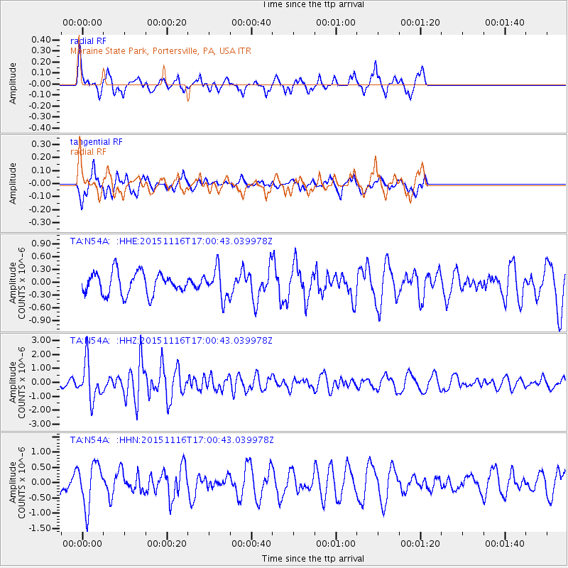
N54A Moraine State Park, Portersville, PA, USA - Earthquake Result Viewer
*The percent match for this event was below the threshold and hence no stack was calculated.
| Earthquake location: |
Kuril Islands |
| Earthquake latitude/longitude: |
48.3/154.3 |
| Earthquake time(UTC): |
2015/11/16 (320) 16:49:15 GMT |
| Earthquake Depth: |
42 km |
| Earthquake Magnitude: |
5.8 MWB |
| Earthquake Catalog/Contributor: |
NEIC PDE/NEIC COMCAT |
|
| Network: |
TA USArray Transportable Network (new EarthScope stations) |
| Station: |
N54A Moraine State Park, Portersville, PA, USA |
| Lat/Lon: |
40.96 N/79.99 W |
| Elevation: |
408 m |
|
| Distance: |
79.0 deg |
| Az: |
38.766 deg |
| Baz: |
326.489 deg |
| Ray Param: |
$rayparam |
*The percent match for this event was below the threshold and hence was not used in the summary stack. |
|
| Radial Match: |
63.456703 % |
| Radial Bump: |
349 |
| Transverse Match: |
72.83487 % |
| Transverse Bump: |
400 |
| SOD ConfigId: |
7422571 |
| Insert Time: |
2019-04-21 09:36:56.543 +0000 |
| GWidth: |
2.5 |
| Max Bumps: |
400 |
| Tol: |
0.001 |
|
Signal To Noise
| Channel | StoN | STA | LTA |
| TA:N54A: :HHZ:20151116T17:00:43.039978Z | 4.154465 | 1.3860229E-6 | 3.3362244E-7 |
| TA:N54A: :HHN:20151116T17:00:43.039978Z | 2.4503186 | 7.18687E-7 | 2.933035E-7 |
| TA:N54A: :HHE:20151116T17:00:43.039978Z | 1.4971255 | 3.7789187E-7 | 2.524116E-7 |
| Arrivals |
| Ps | |
| PpPs | |
| PsPs/PpSs | |


