You are here: Home > Network List > TA - USArray Transportable Network (new EarthScope stations) Stations List
> Station TCOL CIGO, UAF Yankovich Road, Fairbanks, AK, USA > Earthquake Result Viewer
TCOL CIGO, UAF Yankovich Road, Fairbanks, AK, USA - Earthquake Result Viewer
| Earthquake location: |
Kuril Islands |
| Earthquake latitude/longitude: |
48.3/154.3 |
| Earthquake time(UTC): |
2015/11/16 (320) 16:49:15 GMT |
| Earthquake Depth: |
42 km |
| Earthquake Magnitude: |
5.8 MWB |
| Earthquake Catalog/Contributor: |
NEIC PDE/NEIC COMCAT |
|
| Network: |
TA USArray Transportable Network (new EarthScope stations) |
| Station: |
TCOL CIGO, UAF Yankovich Road, Fairbanks, AK, USA |
| Lat/Lon: |
64.87 N/147.86 W |
| Elevation: |
178 m |
|
| Distance: |
34.4 deg |
| Az: |
39.745 deg |
| Baz: |
269.666 deg |
| Ray Param: |
0.07765133 |
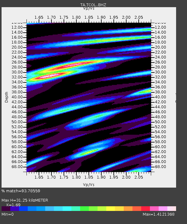
| Estimated Moho Depth: |
31.25 km |
| Estimated Crust Vp/Vs: |
1.69 |
| Assumed Crust Vp: |
6.566 km/s |
| Estimated Crust Vs: |
3.885 km/s |
| Estimated Crust Poisson's Ratio: |
0.23 |
|
| Radial Match: |
93.78559 % |
| Radial Bump: |
400 |
| Transverse Match: |
73.10582 % |
| Transverse Bump: |
400 |
| SOD ConfigId: |
7422571 |
| Insert Time: |
2019-04-21 09:37:13.780 +0000 |
| GWidth: |
2.5 |
| Max Bumps: |
400 |
| Tol: |
0.001 |
|

Signal To Noise
| Channel | StoN | STA | LTA |
| TA:TCOL: :BHZ:20151116T16:55:27.575012Z | 18.596544 | 2.8500388E-6 | 1.5325637E-7 |
| TA:TCOL: :BHN:20151116T16:55:27.575012Z | 6.481072 | 1.5886994E-6 | 2.4512912E-7 |
| TA:TCOL: :BHE:20151116T16:55:27.575012Z | 11.130061 | 2.260145E-6 | 2.0306672E-7 |
| Arrivals |
| Ps | 3.6 SECOND |
| PpPs | 12 SECOND |
| PsPs/PpSs | 15 SECOND |


