You are here: Home > Network List > TA - USArray Transportable Network (new EarthScope stations) Stations List
> Station TUL1 Leonard, OK, USA > Earthquake Result Viewer
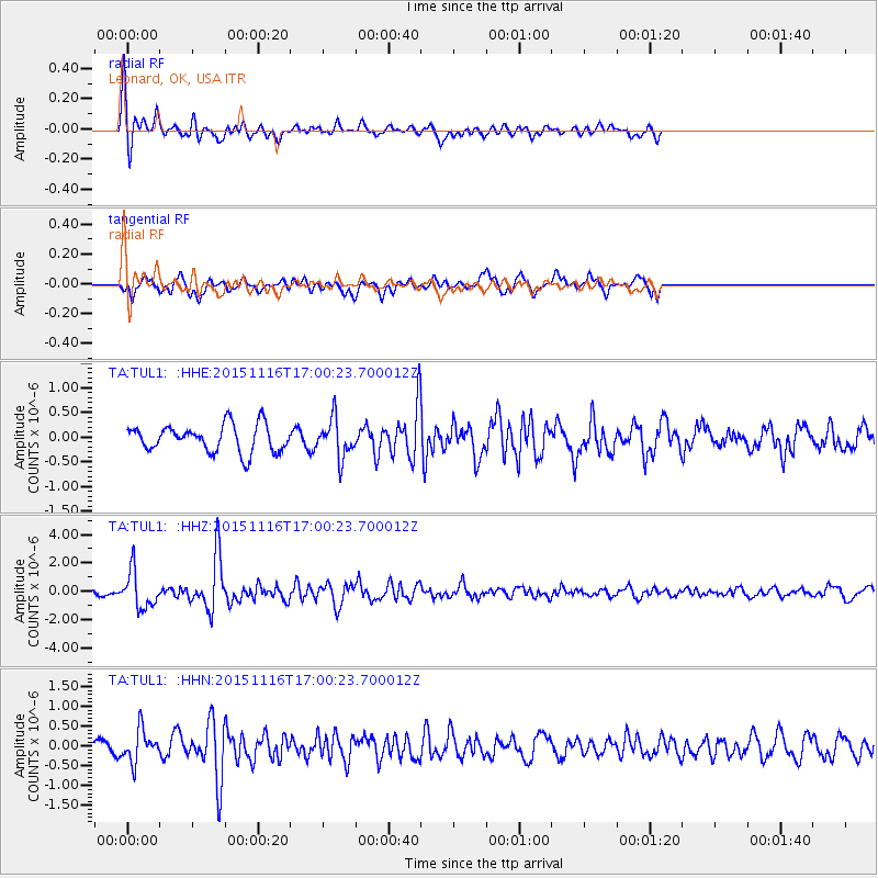
TUL1 Leonard, OK, USA - Earthquake Result Viewer
*The percent match for this event was below the threshold and hence no stack was calculated.
| Earthquake location: |
Kuril Islands |
| Earthquake latitude/longitude: |
48.3/154.3 |
| Earthquake time(UTC): |
2015/11/16 (320) 16:49:15 GMT |
| Earthquake Depth: |
42 km |
| Earthquake Magnitude: |
5.8 MWB |
| Earthquake Catalog/Contributor: |
NEIC PDE/NEIC COMCAT |
|
| Network: |
TA USArray Transportable Network (new EarthScope stations) |
| Station: |
TUL1 Leonard, OK, USA |
| Lat/Lon: |
35.91 N/95.79 W |
| Elevation: |
256 m |
|
| Distance: |
75.5 deg |
| Az: |
52.007 deg |
| Baz: |
319.589 deg |
| Ray Param: |
$rayparam |
*The percent match for this event was below the threshold and hence was not used in the summary stack. |
|
| Radial Match: |
73.100876 % |
| Radial Bump: |
400 |
| Transverse Match: |
58.20655 % |
| Transverse Bump: |
400 |
| SOD ConfigId: |
7422571 |
| Insert Time: |
2019-04-21 09:37:17.243 +0000 |
| GWidth: |
2.5 |
| Max Bumps: |
400 |
| Tol: |
0.001 |
|
Signal To Noise
| Channel | StoN | STA | LTA |
| TA:TUL1: :HHZ:20151116T17:00:23.700012Z | 6.397946 | 1.288305E-6 | 2.013623E-7 |
| TA:TUL1: :HHN:20151116T17:00:23.700012Z | 2.5886421 | 4.011944E-7 | 1.5498257E-7 |
| TA:TUL1: :HHE:20151116T17:00:23.700012Z | 1.4179825 | 3.8759043E-7 | 2.7333937E-7 |
| Arrivals |
| Ps | |
| PpPs | |
| PsPs/PpSs | |


