You are here: Home > Network List > TA - USArray Transportable Network (new EarthScope stations) Stations List
> Station W39A Magazine, AR, USA > Earthquake Result Viewer
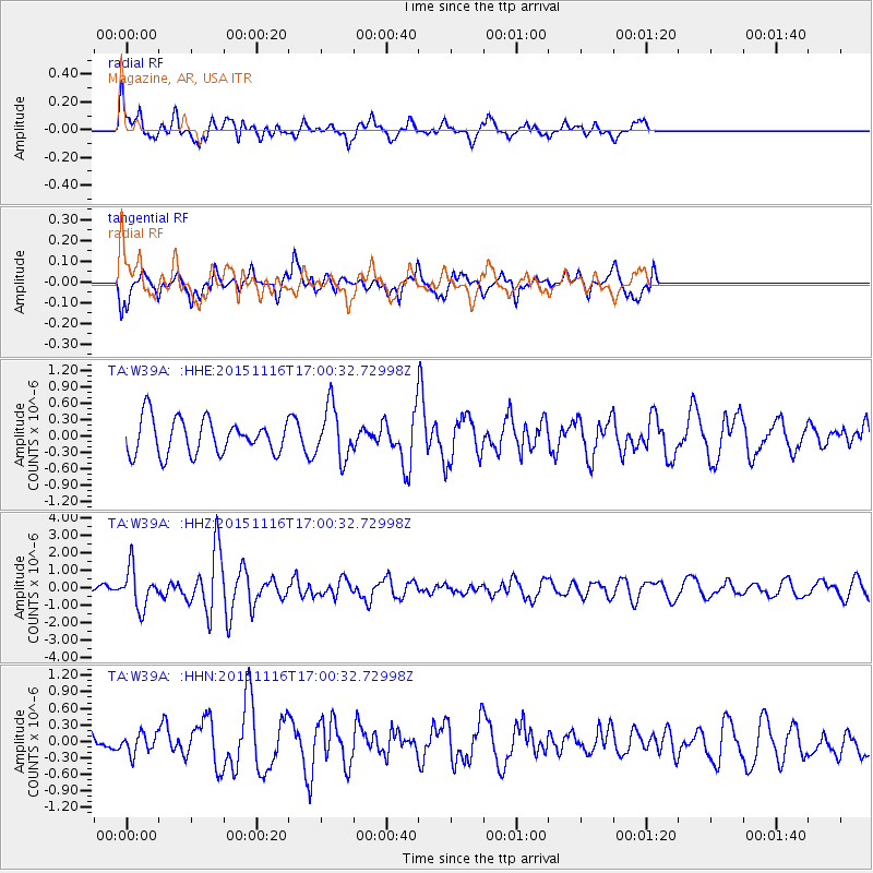
W39A Magazine, AR, USA - Earthquake Result Viewer
*The percent match for this event was below the threshold and hence no stack was calculated.
| Earthquake location: |
Kuril Islands |
| Earthquake latitude/longitude: |
48.3/154.3 |
| Earthquake time(UTC): |
2015/11/16 (320) 16:49:15 GMT |
| Earthquake Depth: |
42 km |
| Earthquake Magnitude: |
5.8 MWB |
| Earthquake Catalog/Contributor: |
NEIC PDE/NEIC COMCAT |
|
| Network: |
TA USArray Transportable Network (new EarthScope stations) |
| Station: |
W39A Magazine, AR, USA |
| Lat/Lon: |
35.20 N/93.78 W |
| Elevation: |
162 m |
|
| Distance: |
77.1 deg |
| Az: |
51.186 deg |
| Baz: |
320.557 deg |
| Ray Param: |
$rayparam |
*The percent match for this event was below the threshold and hence was not used in the summary stack. |
|
| Radial Match: |
53.84301 % |
| Radial Bump: |
400 |
| Transverse Match: |
56.786987 % |
| Transverse Bump: |
400 |
| SOD ConfigId: |
7422571 |
| Insert Time: |
2019-04-21 09:37:18.914 +0000 |
| GWidth: |
2.5 |
| Max Bumps: |
400 |
| Tol: |
0.001 |
|
Signal To Noise
| Channel | StoN | STA | LTA |
| TA:W39A: :HHZ:20151116T17:00:32.72998Z | 2.6491516 | 1.1178644E-6 | 4.2197073E-7 |
| TA:W39A: :HHN:20151116T17:00:32.72998Z | 0.83924556 | 1.8294367E-7 | 2.1798584E-7 |
| TA:W39A: :HHE:20151116T17:00:32.72998Z | 1.4888866 | 4.7929456E-7 | 3.2191477E-7 |
| Arrivals |
| Ps | |
| PpPs | |
| PsPs/PpSs | |


