You are here: Home > Network List > US - United States National Seismic Network Stations List
> Station DGMT Dagmar, Montana, USA > Earthquake Result Viewer
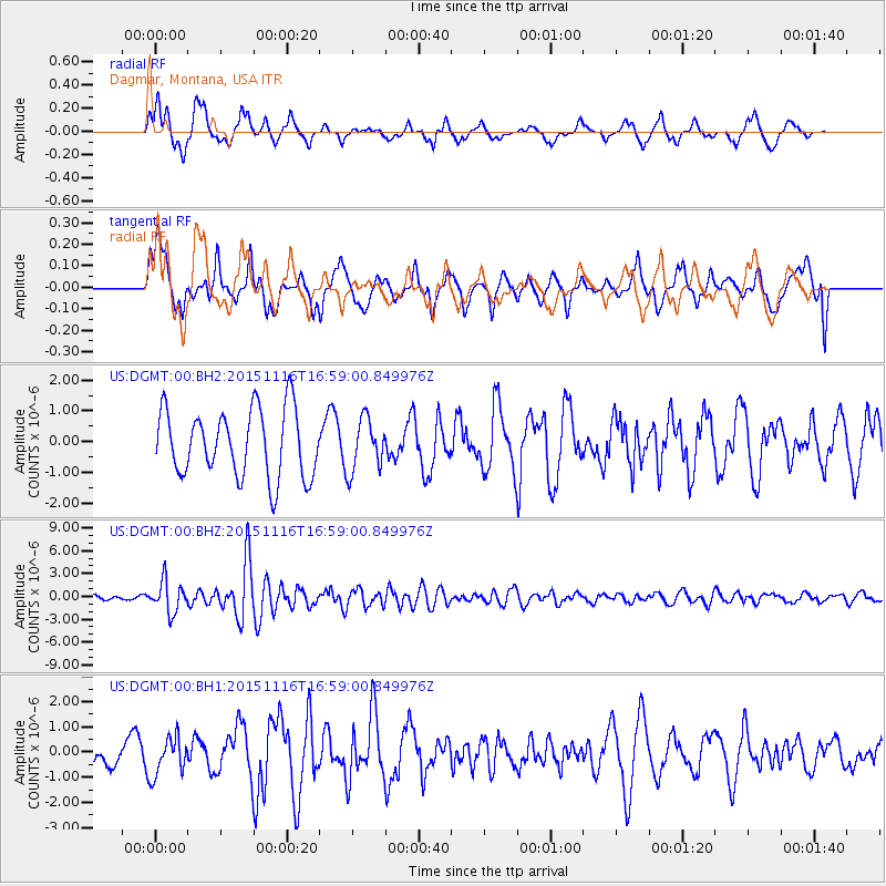
DGMT Dagmar, Montana, USA - Earthquake Result Viewer
*The percent match for this event was below the threshold and hence no stack was calculated.
| Earthquake location: |
Kuril Islands |
| Earthquake latitude/longitude: |
48.3/154.3 |
| Earthquake time(UTC): |
2015/11/16 (320) 16:49:15 GMT |
| Earthquake Depth: |
42 km |
| Earthquake Magnitude: |
5.8 MWB |
| Earthquake Catalog/Contributor: |
NEIC PDE/NEIC COMCAT |
|
| Network: |
US United States National Seismic Network |
| Station: |
DGMT Dagmar, Montana, USA |
| Lat/Lon: |
48.47 N/104.20 W |
| Elevation: |
0.0 m |
|
| Distance: |
62.2 deg |
| Az: |
47.498 deg |
| Baz: |
312.288 deg |
| Ray Param: |
$rayparam |
*The percent match for this event was below the threshold and hence was not used in the summary stack. |
|
| Radial Match: |
61.509354 % |
| Radial Bump: |
400 |
| Transverse Match: |
47.077377 % |
| Transverse Bump: |
400 |
| SOD ConfigId: |
7422571 |
| Insert Time: |
2019-04-21 09:37:42.004 +0000 |
| GWidth: |
2.5 |
| Max Bumps: |
400 |
| Tol: |
0.001 |
|
Signal To Noise
| Channel | StoN | STA | LTA |
| US:DGMT:00:BHZ:20151116T16:59:00.849976Z | 5.7351093 | 2.01559E-6 | 3.5144754E-7 |
| US:DGMT:00:BH1:20151116T16:59:00.849976Z | 1.7535665 | 7.35006E-7 | 4.191492E-7 |
| US:DGMT:00:BH2:20151116T16:59:00.849976Z | 0.64603007 | 7.039772E-7 | 1.0896973E-6 |
| Arrivals |
| Ps | |
| PpPs | |
| PsPs/PpSs | |


