You are here: Home > Network List > US - United States National Seismic Network Stations List
> Station RLMT Red Lodge, Montana, USA > Earthquake Result Viewer
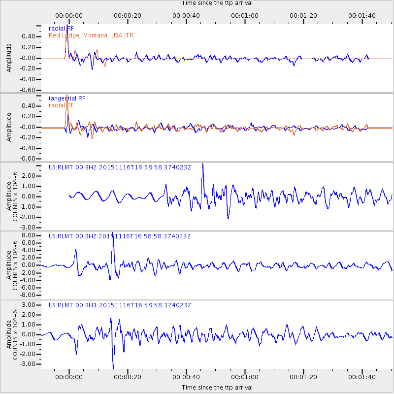
RLMT Red Lodge, Montana, USA - Earthquake Result Viewer
*The percent match for this event was below the threshold and hence no stack was calculated.
| Earthquake location: |
Kuril Islands |
| Earthquake latitude/longitude: |
48.3/154.3 |
| Earthquake time(UTC): |
2015/11/16 (320) 16:49:15 GMT |
| Earthquake Depth: |
42 km |
| Earthquake Magnitude: |
5.8 MWB |
| Earthquake Catalog/Contributor: |
NEIC PDE/NEIC COMCAT |
|
| Network: |
US United States National Seismic Network |
| Station: |
RLMT Red Lodge, Montana, USA |
| Lat/Lon: |
45.12 N/109.27 W |
| Elevation: |
2086 m |
|
| Distance: |
61.8 deg |
| Az: |
52.955 deg |
| Baz: |
311.164 deg |
| Ray Param: |
$rayparam |
*The percent match for this event was below the threshold and hence was not used in the summary stack. |
|
| Radial Match: |
79.681755 % |
| Radial Bump: |
386 |
| Transverse Match: |
75.182304 % |
| Transverse Bump: |
400 |
| SOD ConfigId: |
7422571 |
| Insert Time: |
2019-04-21 09:37:47.500 +0000 |
| GWidth: |
2.5 |
| Max Bumps: |
400 |
| Tol: |
0.001 |
|
Signal To Noise
| Channel | StoN | STA | LTA |
| US:RLMT:00:BHZ:20151116T16:58:58.374023Z | 10.601529 | 1.8965192E-6 | 1.7889109E-7 |
| US:RLMT:00:BH1:20151116T16:58:58.374023Z | 5.046441 | 7.75102E-7 | 1.535938E-7 |
| US:RLMT:00:BH2:20151116T16:58:58.374023Z | 1.6980025 | 4.955742E-7 | 2.9185722E-7 |
| Arrivals |
| Ps | |
| PpPs | |
| PsPs/PpSs | |


