You are here: Home > Network List > AV - Alaska Volcano Observatory Stations List
> Station MAPS Pakushin Southeast, Makushin Volcano, Alaska > Earthquake Result Viewer
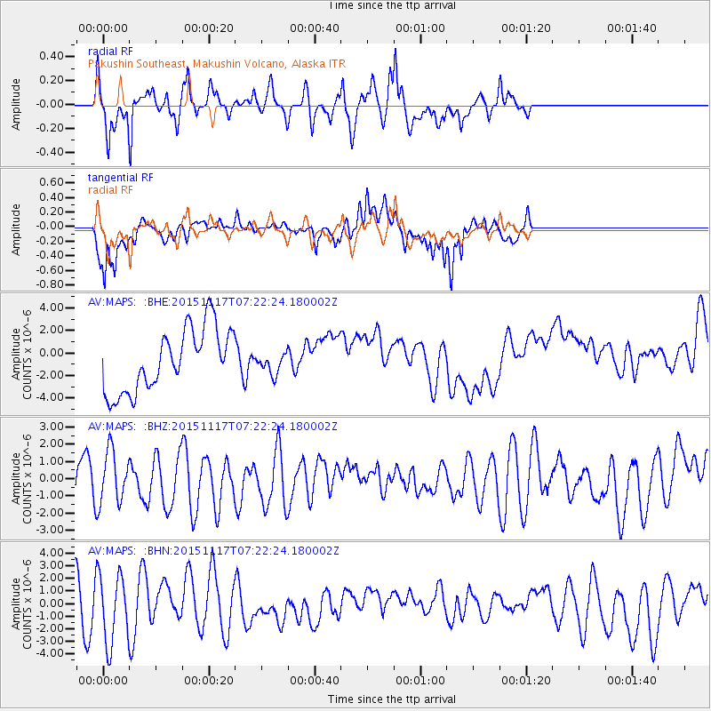
MAPS Pakushin Southeast, Makushin Volcano, Alaska - Earthquake Result Viewer
*The percent match for this event was below the threshold and hence no stack was calculated.
| Earthquake location: |
Greece |
| Earthquake latitude/longitude: |
38.8/20.6 |
| Earthquake time(UTC): |
2015/11/17 (321) 07:10:08 GMT |
| Earthquake Depth: |
11 km |
| Earthquake Magnitude: |
6.5 MWB |
| Earthquake Catalog/Contributor: |
NEIC PDE/NEIC COMCAT |
|
| Network: |
AV Alaska Volcano Observatory |
| Station: |
MAPS Pakushin Southeast, Makushin Volcano, Alaska |
| Lat/Lon: |
53.81 N/166.94 W |
| Elevation: |
333 m |
|
| Distance: |
87.6 deg |
| Az: |
4.439 deg |
| Baz: |
354.143 deg |
| Ray Param: |
$rayparam |
*The percent match for this event was below the threshold and hence was not used in the summary stack. |
|
| Radial Match: |
74.86232 % |
| Radial Bump: |
385 |
| Transverse Match: |
73.99065 % |
| Transverse Bump: |
359 |
| SOD ConfigId: |
7422571 |
| Insert Time: |
2019-04-21 09:42:14.799 +0000 |
| GWidth: |
2.5 |
| Max Bumps: |
400 |
| Tol: |
0.001 |
|
Signal To Noise
| Channel | StoN | STA | LTA |
| AV:MAPS: :BHZ:20151117T07:22:24.180002Z | 1.1259471 | 1.4942103E-6 | 1.3270698E-6 |
| AV:MAPS: :BHN:20151117T07:22:24.180002Z | 1.3369265 | 2.7155545E-6 | 2.031192E-6 |
| AV:MAPS: :BHE:20151117T07:22:24.180002Z | 0.38506156 | 1.0475852E-6 | 2.7205656E-6 |
| Arrivals |
| Ps | |
| PpPs | |
| PsPs/PpSs | |


