You are here: Home > Network List > CI - Caltech Regional Seismic Network Stations List
> Station PAS Pasadena, California, USA > Earthquake Result Viewer
PAS Pasadena, California, USA - Earthquake Result Viewer
| Earthquake location: |
Tonga Islands |
| Earthquake latitude/longitude: |
-15.2/-175.6 |
| Earthquake time(UTC): |
1997/08/29 (241) 06:54:00 GMT |
| Earthquake Depth: |
33 km |
| Earthquake Magnitude: |
5.6 MB, 6.4 MS, 6.5 UNKNOWN, 6.4 MW |
| Earthquake Catalog/Contributor: |
WHDF/NEIC |
|
| Network: |
CI Caltech Regional Seismic Network |
| Station: |
PAS Pasadena, California, USA |
| Lat/Lon: |
34.15 N/118.17 W |
| Elevation: |
257 m |
|
| Distance: |
73.4 deg |
| Az: |
46.804 deg |
| Baz: |
238.054 deg |
| Ray Param: |
0.052967377 |
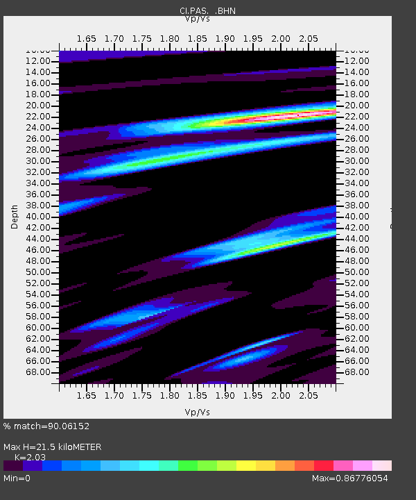
| Estimated Moho Depth: |
21.5 km |
| Estimated Crust Vp/Vs: |
2.03 |
| Assumed Crust Vp: |
6.1 km/s |
| Estimated Crust Vs: |
3.005 km/s |
| Estimated Crust Poisson's Ratio: |
0.34 |
|
| Radial Match: |
90.06152 % |
| Radial Bump: |
400 |
| Transverse Match: |
81.45392 % |
| Transverse Bump: |
400 |
| SOD ConfigId: |
4770 |
| Insert Time: |
2010-02-25 23:56:22.968 +0000 |
| GWidth: |
2.5 |
| Max Bumps: |
400 |
| Tol: |
0.001 |
|

Signal To Noise
| Channel | StoN | STA | LTA |
| CI:PAS: :BHN:19970829T07:04:58.116016Z | 0.666469 | 1.5674769E-7 | 2.3519128E-7 |
| CI:PAS: :BHE:19970829T07:04:58.116016Z | 1.0441216 | 1.17995526E-7 | 1.13009364E-7 |
| CI:PAS: :BHZ:19970829T07:04:58.116016Z | 0.7426646 | 1.5903986E-7 | 2.1414763E-7 |
| Arrivals |
| Ps | 3.7 SECOND |
| PpPs | 10 SECOND |
| PsPs/PpSs | 14 SECOND |


