You are here: Home > Network List > TA - USArray Transportable Network (new EarthScope stations) Stations List
> Station M53A WI Miller and Sons, Farmdale, OH, USA > Earthquake Result Viewer
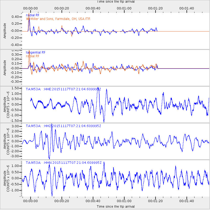
M53A WI Miller and Sons, Farmdale, OH, USA - Earthquake Result Viewer
*The percent match for this event was below the threshold and hence no stack was calculated.
| Earthquake location: |
Greece |
| Earthquake latitude/longitude: |
38.8/20.6 |
| Earthquake time(UTC): |
2015/11/17 (321) 07:10:08 GMT |
| Earthquake Depth: |
11 km |
| Earthquake Magnitude: |
6.5 MWB |
| Earthquake Catalog/Contributor: |
NEIC PDE/NEIC COMCAT |
|
| Network: |
TA USArray Transportable Network (new EarthScope stations) |
| Station: |
M53A WI Miller and Sons, Farmdale, OH, USA |
| Lat/Lon: |
41.44 N/80.68 W |
| Elevation: |
334 m |
|
| Distance: |
72.7 deg |
| Az: |
309.447 deg |
| Baz: |
53.422 deg |
| Ray Param: |
$rayparam |
*The percent match for this event was below the threshold and hence was not used in the summary stack. |
|
| Radial Match: |
71.24993 % |
| Radial Bump: |
400 |
| Transverse Match: |
45.04117 % |
| Transverse Bump: |
319 |
| SOD ConfigId: |
7422571 |
| Insert Time: |
2019-04-21 09:48:54.997 +0000 |
| GWidth: |
2.5 |
| Max Bumps: |
400 |
| Tol: |
0.001 |
|
Signal To Noise
| Channel | StoN | STA | LTA |
| TA:M53A: :HHZ:20151117T07:21:04.609995Z | 2.2999184 | 7.41695E-7 | 3.2248752E-7 |
| TA:M53A: :HHN:20151117T07:21:04.609995Z | 2.6767924 | 5.397646E-7 | 2.0164605E-7 |
| TA:M53A: :HHE:20151117T07:21:04.609995Z | 1.9323666 | 4.467926E-7 | 2.3121522E-7 |
| Arrivals |
| Ps | |
| PpPs | |
| PsPs/PpSs | |


