You are here: Home > Network List > TA - USArray Transportable Network (new EarthScope stations) Stations List
> Station N54A Moraine State Park, Portersville, PA, USA > Earthquake Result Viewer
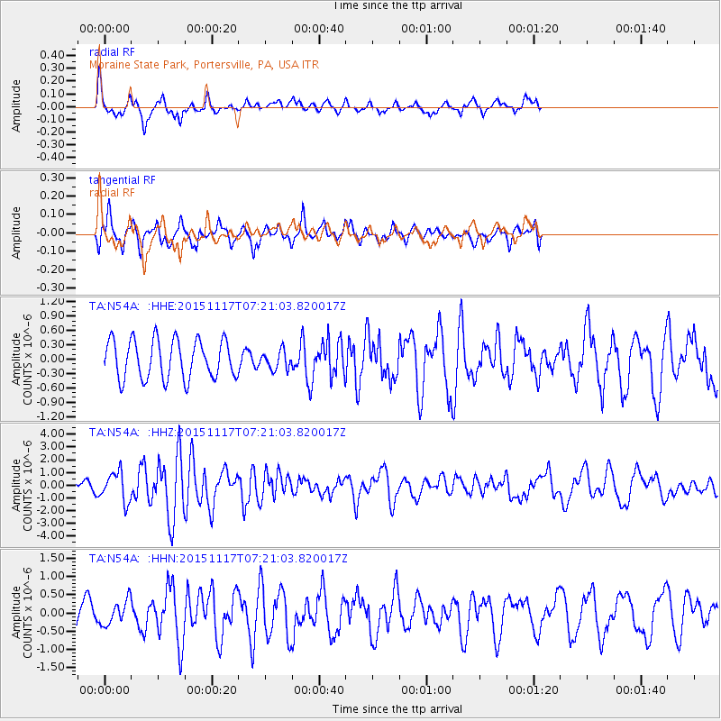
N54A Moraine State Park, Portersville, PA, USA - Earthquake Result Viewer
*The percent match for this event was below the threshold and hence no stack was calculated.
| Earthquake location: |
Greece |
| Earthquake latitude/longitude: |
38.8/20.6 |
| Earthquake time(UTC): |
2015/11/17 (321) 07:10:08 GMT |
| Earthquake Depth: |
11 km |
| Earthquake Magnitude: |
6.5 MWB |
| Earthquake Catalog/Contributor: |
NEIC PDE/NEIC COMCAT |
|
| Network: |
TA USArray Transportable Network (new EarthScope stations) |
| Station: |
N54A Moraine State Park, Portersville, PA, USA |
| Lat/Lon: |
40.96 N/79.99 W |
| Elevation: |
408 m |
|
| Distance: |
72.6 deg |
| Az: |
308.723 deg |
| Baz: |
53.657 deg |
| Ray Param: |
$rayparam |
*The percent match for this event was below the threshold and hence was not used in the summary stack. |
|
| Radial Match: |
72.58715 % |
| Radial Bump: |
400 |
| Transverse Match: |
74.03051 % |
| Transverse Bump: |
360 |
| SOD ConfigId: |
7422571 |
| Insert Time: |
2019-04-21 09:48:57.996 +0000 |
| GWidth: |
2.5 |
| Max Bumps: |
400 |
| Tol: |
0.001 |
|
Signal To Noise
| Channel | StoN | STA | LTA |
| TA:N54A: :HHZ:20151117T07:21:03.820017Z | 3.2310114 | 1.1622732E-6 | 3.5972428E-7 |
| TA:N54A: :HHN:20151117T07:21:03.820017Z | 1.2611102 | 3.356062E-7 | 2.6611966E-7 |
| TA:N54A: :HHE:20151117T07:21:03.820017Z | 0.4873981 | 1.9701442E-7 | 4.0421665E-7 |
| Arrivals |
| Ps | |
| PpPs | |
| PsPs/PpSs | |


