You are here: Home > Network List > US - United States National Seismic Network Stations List
> Station LAO LASA Array, Montana, USA > Earthquake Result Viewer
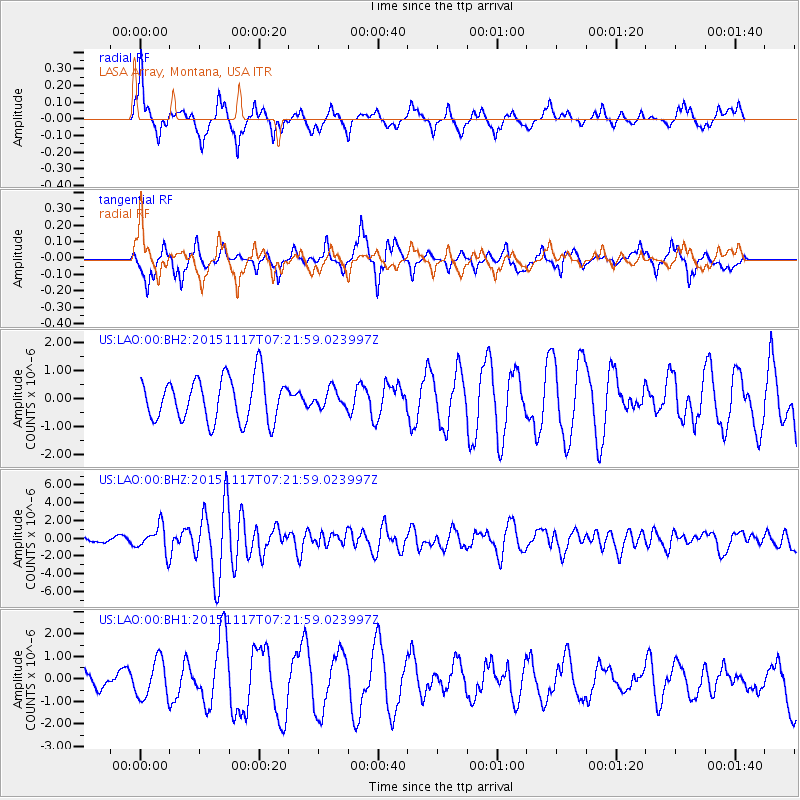
LAO LASA Array, Montana, USA - Earthquake Result Viewer
*The percent match for this event was below the threshold and hence no stack was calculated.
| Earthquake location: |
Greece |
| Earthquake latitude/longitude: |
38.8/20.6 |
| Earthquake time(UTC): |
2015/11/17 (321) 07:10:08 GMT |
| Earthquake Depth: |
11 km |
| Earthquake Magnitude: |
6.5 MWB |
| Earthquake Catalog/Contributor: |
NEIC PDE/NEIC COMCAT |
|
| Network: |
US United States National Seismic Network |
| Station: |
LAO LASA Array, Montana, USA |
| Lat/Lon: |
46.69 N/106.22 W |
| Elevation: |
902 m |
|
| Distance: |
82.5 deg |
| Az: |
326.212 deg |
| Baz: |
39.171 deg |
| Ray Param: |
$rayparam |
*The percent match for this event was below the threshold and hence was not used in the summary stack. |
|
| Radial Match: |
63.97108 % |
| Radial Bump: |
341 |
| Transverse Match: |
66.62958 % |
| Transverse Bump: |
396 |
| SOD ConfigId: |
7422571 |
| Insert Time: |
2019-04-21 09:49:42.730 +0000 |
| GWidth: |
2.5 |
| Max Bumps: |
400 |
| Tol: |
0.001 |
|
Signal To Noise
| Channel | StoN | STA | LTA |
| US:LAO:00:BHZ:20151117T07:21:59.023997Z | 5.6777773 | 1.5083042E-6 | 2.6565047E-7 |
| US:LAO:00:BH1:20151117T07:21:59.023997Z | 1.7046479 | 8.5620337E-7 | 5.022758E-7 |
| US:LAO:00:BH2:20151117T07:21:59.023997Z | 0.50163054 | 3.8224297E-7 | 7.62001E-7 |
| Arrivals |
| Ps | |
| PpPs | |
| PsPs/PpSs | |


