You are here: Home > Network List > TA - USArray Transportable Network (new EarthScope stations) Stations List
> Station O48A Farmland, IN, USA > Earthquake Result Viewer
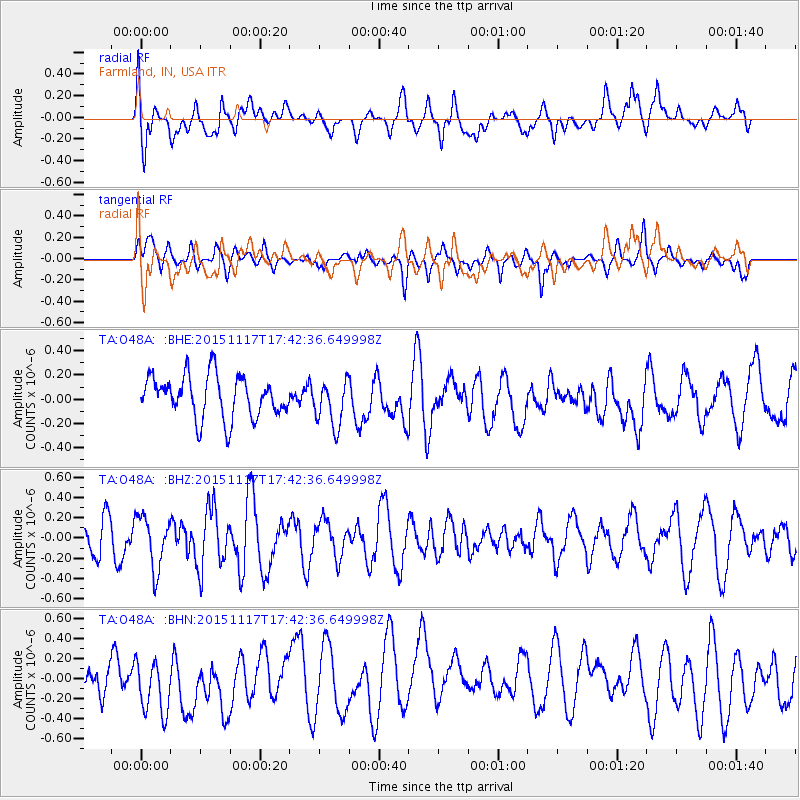
O48A Farmland, IN, USA - Earthquake Result Viewer
*The percent match for this event was below the threshold and hence no stack was calculated.
| Earthquake location: |
Kyrgyzstan |
| Earthquake latitude/longitude: |
40.4/73.1 |
| Earthquake time(UTC): |
2015/11/17 (321) 17:29:36 GMT |
| Earthquake Depth: |
16 km |
| Earthquake Magnitude: |
5.5 MWR |
| Earthquake Catalog/Contributor: |
NEIC PDE/NEIC COMCAT |
|
| Network: |
TA USArray Transportable Network (new EarthScope stations) |
| Station: |
O48A Farmland, IN, USA |
| Lat/Lon: |
40.26 N/85.16 W |
| Elevation: |
300 m |
|
| Distance: |
97.3 deg |
| Az: |
343.412 deg |
| Baz: |
16.559 deg |
| Ray Param: |
$rayparam |
*The percent match for this event was below the threshold and hence was not used in the summary stack. |
|
| Radial Match: |
55.410927 % |
| Radial Bump: |
400 |
| Transverse Match: |
56.02117 % |
| Transverse Bump: |
400 |
| SOD ConfigId: |
7422571 |
| Insert Time: |
2019-04-21 09:57:20.453 +0000 |
| GWidth: |
2.5 |
| Max Bumps: |
400 |
| Tol: |
0.001 |
|
Signal To Noise
| Channel | StoN | STA | LTA |
| TA:O48A: :BHZ:20151117T17:42:36.649998Z | 1.7384979 | 2.595525E-7 | 1.49297E-7 |
| TA:O48A: :BHN:20151117T17:42:36.649998Z | 1.0634097 | 3.2799431E-7 | 3.0843646E-7 |
| TA:O48A: :BHE:20151117T17:42:36.649998Z | 1.1218156 | 1.9353782E-7 | 1.7252195E-7 |
| Arrivals |
| Ps | |
| PpPs | |
| PsPs/PpSs | |


