You are here: Home > Network List > AT - Alaska Tsunami Warning Seismic System Stations List
> Station CHGN Chignik, Alaska > Earthquake Result Viewer
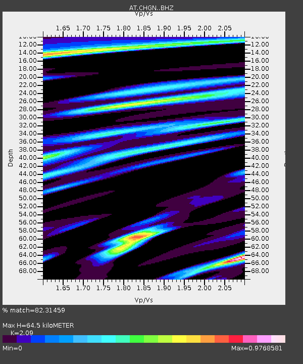
CHGN Chignik, Alaska - Earthquake Result Viewer
| Earthquake location: |
Solomon Islands |
| Earthquake latitude/longitude: |
-8.9/158.4 |
| Earthquake time(UTC): |
2015/11/18 (322) 18:31:04 GMT |
| Earthquake Depth: |
11 km |
| Earthquake Magnitude: |
6.8 MWB, 7.0 MI |
| Earthquake Catalog/Contributor: |
NEIC PDE/NEIC COMCAT |
|
| Network: |
AT Alaska Tsunami Warning Seismic System |
| Station: |
CHGN Chignik, Alaska |
| Lat/Lon: |
56.30 N/158.41 W |
| Elevation: |
17 m |
|
| Distance: |
74.1 deg |
| Az: |
23.355 deg |
| Baz: |
224.641 deg |
| Ray Param: |
0.0525374 |
| Estimated Moho Depth: |
64.5 km |
| Estimated Crust Vp/Vs: |
2.09 |
| Assumed Crust Vp: |
6.134 km/s |
| Estimated Crust Vs: |
2.935 km/s |
| Estimated Crust Poisson's Ratio: |
0.35 |
|
| Radial Match: |
82.31459 % |
| Radial Bump: |
400 |
| Transverse Match: |
78.49644 % |
| Transverse Bump: |
400 |
| SOD ConfigId: |
7422571 |
| Insert Time: |
2019-04-21 10:01:04.821 +0000 |
| GWidth: |
2.5 |
| Max Bumps: |
400 |
| Tol: |
0.001 |
|

Signal To Noise
| Channel | StoN | STA | LTA |
| AT:CHGN: :BHZ:20151118T18:42:09.020022Z | 6.260946 | 2.6779126E-6 | 4.277169E-7 |
| AT:CHGN: :BHN:20151118T18:42:09.020022Z | 1.8340348 | 1.1514038E-6 | 6.277982E-7 |
| AT:CHGN: :BHE:20151118T18:42:09.020022Z | 1.4598559 | 8.5111174E-7 | 5.830108E-7 |
| Arrivals |
| Ps | 12 SECOND |
| PpPs | 32 SECOND |
| PsPs/PpSs | 43 SECOND |


