You are here: Home > Network List > AV - Alaska Volcano Observatory Stations List
> Station MNAT Nateekin Bay, Makushin Volcano, Alaska > Earthquake Result Viewer
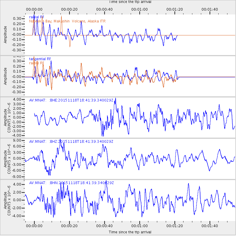
MNAT Nateekin Bay, Makushin Volcano, Alaska - Earthquake Result Viewer
*The percent match for this event was below the threshold and hence no stack was calculated.
| Earthquake location: |
Solomon Islands |
| Earthquake latitude/longitude: |
-8.9/158.4 |
| Earthquake time(UTC): |
2015/11/18 (322) 18:31:04 GMT |
| Earthquake Depth: |
11 km |
| Earthquake Magnitude: |
6.8 MWB, 7.0 MI |
| Earthquake Catalog/Contributor: |
NEIC PDE/NEIC COMCAT |
|
| Network: |
AV Alaska Volcano Observatory |
| Station: |
MNAT Nateekin Bay, Makushin Volcano, Alaska |
| Lat/Lon: |
53.88 N/166.69 W |
| Elevation: |
390 m |
|
| Distance: |
69.2 deg |
| Az: |
21.242 deg |
| Baz: |
217.202 deg |
| Ray Param: |
$rayparam |
*The percent match for this event was below the threshold and hence was not used in the summary stack. |
|
| Radial Match: |
78.24222 % |
| Radial Bump: |
400 |
| Transverse Match: |
55.55187 % |
| Transverse Bump: |
400 |
| SOD ConfigId: |
7422571 |
| Insert Time: |
2019-04-21 10:01:21.909 +0000 |
| GWidth: |
2.5 |
| Max Bumps: |
400 |
| Tol: |
0.001 |
|
Signal To Noise
| Channel | StoN | STA | LTA |
| AV:MNAT: :BHZ:20151118T18:41:39.340029Z | 2.8166564 | 2.1030196E-6 | 7.466369E-7 |
| AV:MNAT: :BHN:20151118T18:41:39.340029Z | 1.0976079 | 1.2472109E-6 | 1.1362991E-6 |
| AV:MNAT: :BHE:20151118T18:41:39.340029Z | 1.206894 | 9.77919E-7 | 8.102774E-7 |
| Arrivals |
| Ps | |
| PpPs | |
| PsPs/PpSs | |


