You are here: Home > Network List > CB - China National Seismic Network Stations List
> Station LZH Lanzhou,Gansu Province > Earthquake Result Viewer
LZH Lanzhou,Gansu Province - Earthquake Result Viewer
| Earthquake location: |
Solomon Islands |
| Earthquake latitude/longitude: |
-8.9/158.4 |
| Earthquake time(UTC): |
2015/11/18 (322) 18:31:04 GMT |
| Earthquake Depth: |
11 km |
| Earthquake Magnitude: |
6.8 MWB, 7.0 MI |
| Earthquake Catalog/Contributor: |
NEIC PDE/NEIC COMCAT |
|
| Network: |
CB China National Seismic Network |
| Station: |
LZH Lanzhou,Gansu Province |
| Lat/Lon: |
36.09 N/103.84 E |
| Elevation: |
1560 m |
|
| Distance: |
68.1 deg |
| Az: |
314.645 deg |
| Baz: |
119.793 deg |
| Ray Param: |
0.056534197 |
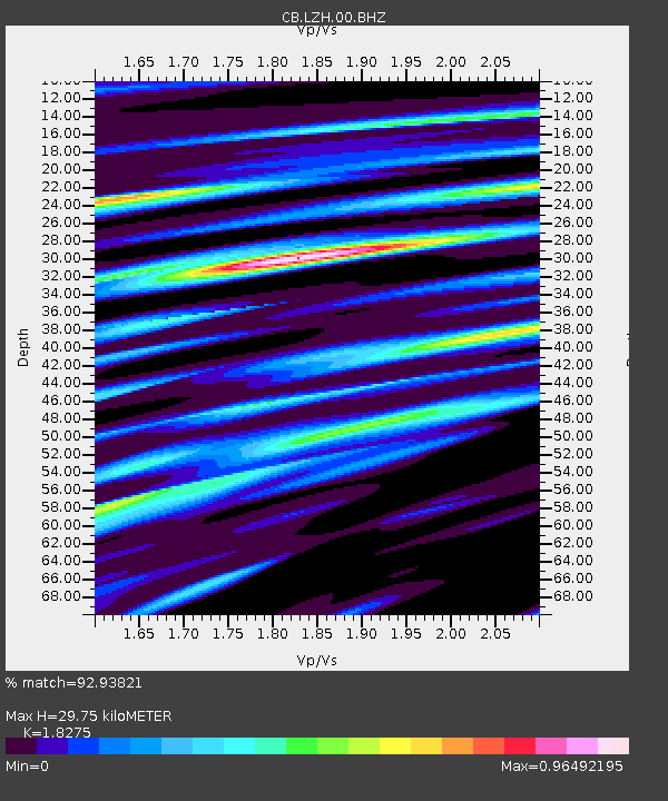
| Estimated Moho Depth: |
29.75 km |
| Estimated Crust Vp/Vs: |
1.83 |
| Assumed Crust Vp: |
6.306 km/s |
| Estimated Crust Vs: |
3.451 km/s |
| Estimated Crust Poisson's Ratio: |
0.29 |
|
| Radial Match: |
92.93821 % |
| Radial Bump: |
400 |
| Transverse Match: |
80.255424 % |
| Transverse Bump: |
400 |
| SOD ConfigId: |
7422571 |
| Insert Time: |
2019-04-21 10:02:15.535 +0000 |
| GWidth: |
2.5 |
| Max Bumps: |
400 |
| Tol: |
0.001 |
|

Signal To Noise
| Channel | StoN | STA | LTA |
| CB:LZH:00:BHZ:20151118T18:41:32.510012Z | 5.732759 | 5.402172E-7 | 9.423337E-8 |
| CB:LZH:00:BHN:20151118T18:41:32.510012Z | 1.8993884 | 2.1896146E-7 | 1.1527998E-7 |
| CB:LZH:00:BHE:20151118T18:41:32.510012Z | 2.3664794 | 2.5596313E-7 | 1.0816199E-7 |
| Arrivals |
| Ps | 4.0 SECOND |
| PpPs | 13 SECOND |
| PsPs/PpSs | 17 SECOND |


