You are here: Home > Network List > IW - Intermountain West Stations List
> Station RWWY Rawlins, Wyoming, USA > Earthquake Result Viewer
RWWY Rawlins, Wyoming, USA - Earthquake Result Viewer
| Earthquake location: |
Off East Coast Of Honshu, Japan |
| Earthquake latitude/longitude: |
39.6/143.3 |
| Earthquake time(UTC): |
2015/06/11 (162) 04:51:24 GMT |
| Earthquake Depth: |
10 km |
| Earthquake Magnitude: |
5.7 MB |
| Earthquake Catalog/Contributor: |
NEIC PDE/NEIC ALERT |
|
| Network: |
IW Intermountain West |
| Station: |
RWWY Rawlins, Wyoming, USA |
| Lat/Lon: |
41.69 N/107.21 W |
| Elevation: |
2402 m |
|
| Distance: |
76.8 deg |
| Az: |
46.495 deg |
| Baz: |
311.588 deg |
| Ray Param: |
0.050742425 |
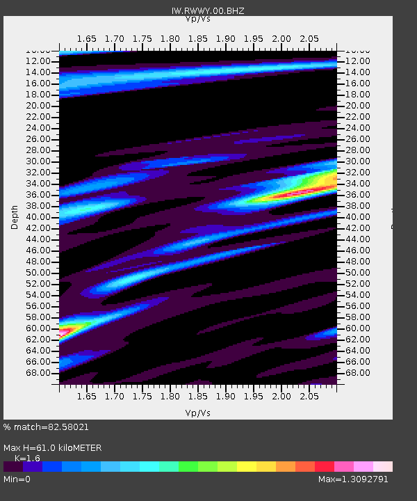
| Estimated Moho Depth: |
61.0 km |
| Estimated Crust Vp/Vs: |
1.60 |
| Assumed Crust Vp: |
6.159 km/s |
| Estimated Crust Vs: |
3.849 km/s |
| Estimated Crust Poisson's Ratio: |
0.18 |
|
| Radial Match: |
82.58021 % |
| Radial Bump: |
400 |
| Transverse Match: |
55.57668 % |
| Transverse Bump: |
400 |
| SOD ConfigId: |
976571 |
| Insert Time: |
2015-06-25 05:15:10.486 +0000 |
| GWidth: |
2.5 |
| Max Bumps: |
400 |
| Tol: |
0.001 |
|

Signal To Noise
| Channel | StoN | STA | LTA |
| IW:RWWY:00:BHZ:20150611T05:02:44.765027Z | 1.9560401 | 1.9377308E-7 | 9.906395E-8 |
| IW:RWWY:00:BH1:20150611T05:02:44.765027Z | 1.1618603 | 1.1938658E-7 | 1.02754676E-7 |
| IW:RWWY:00:BH2:20150611T05:02:44.765027Z | 1.3559332 | 1.10502725E-7 | 8.1495706E-8 |
| Arrivals |
| Ps | 6.1 SECOND |
| PpPs | 25 SECOND |
| PsPs/PpSs | 31 SECOND |


