You are here: Home > Network List > ER - Mount Erebus Volcano Observatory Seismic Network Stations List
> Station ICE Mt Erebus site ICE > Earthquake Result Viewer
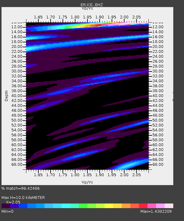
ICE Mt Erebus site ICE - Earthquake Result Viewer
| Earthquake location: |
Solomon Islands |
| Earthquake latitude/longitude: |
-8.9/158.4 |
| Earthquake time(UTC): |
2015/11/18 (322) 18:31:04 GMT |
| Earthquake Depth: |
11 km |
| Earthquake Magnitude: |
6.8 MWB, 7.0 MI |
| Earthquake Catalog/Contributor: |
NEIC PDE/NEIC COMCAT |
|
| Network: |
ER Mount Erebus Volcano Observatory Seismic Network |
| Station: |
ICE Mt Erebus site ICE |
| Lat/Lon: |
77.55 S/167.28 E |
| Elevation: |
2370 m |
|
| Distance: |
68.7 deg |
| Az: |
177.945 deg |
| Baz: |
350.6 deg |
| Ray Param: |
0.05610386 |
| Estimated Moho Depth: |
10.0 km |
| Estimated Crust Vp/Vs: |
2.05 |
| Assumed Crust Vp: |
6.183 km/s |
| Estimated Crust Vs: |
3.016 km/s |
| Estimated Crust Poisson's Ratio: |
0.34 |
|
| Radial Match: |
96.42486 % |
| Radial Bump: |
323 |
| Transverse Match: |
91.40383 % |
| Transverse Bump: |
400 |
| SOD ConfigId: |
7422571 |
| Insert Time: |
2019-04-21 10:03:32.964 +0000 |
| GWidth: |
2.5 |
| Max Bumps: |
400 |
| Tol: |
0.001 |
|

Signal To Noise
| Channel | StoN | STA | LTA |
| ER:ICE: :BHZ:20151118T18:41:37.099978Z | 4.707382 | 1.5966428E-6 | 3.391785E-7 |
| ER:ICE: :BHN:20151118T18:41:37.099978Z | 2.4666126 | 7.412244E-7 | 3.00503E-7 |
| ER:ICE: :BHE:20151118T18:41:37.099978Z | 1.0028661 | 4.4396253E-7 | 4.426937E-7 |
| Arrivals |
| Ps | 1.8 SECOND |
| PpPs | 4.8 SECOND |
| PsPs/PpSs | 6.5 SECOND |


