You are here: Home > Network List > RM - Regional Integrated Multi Hazard Early Warning System Stations List
> Station SLV Son La Vietnam > Earthquake Result Viewer
SLV Son La Vietnam - Earthquake Result Viewer
| Earthquake location: |
Solomon Islands |
| Earthquake latitude/longitude: |
-8.9/158.4 |
| Earthquake time(UTC): |
2015/11/18 (322) 18:31:04 GMT |
| Earthquake Depth: |
11 km |
| Earthquake Magnitude: |
6.8 MWB, 7.0 MI |
| Earthquake Catalog/Contributor: |
NEIC PDE/NEIC COMCAT |
|
| Network: |
RM Regional Integrated Multi Hazard Early Warning System |
| Station: |
SLV Son La Vietnam |
| Lat/Lon: |
21.33 N/103.91 E |
| Elevation: |
630 m |
|
| Distance: |
61.4 deg |
| Az: |
300.142 deg |
| Baz: |
113.596 deg |
| Ray Param: |
0.060903404 |
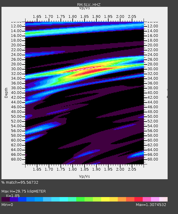
| Estimated Moho Depth: |
29.75 km |
| Estimated Crust Vp/Vs: |
1.85 |
| Assumed Crust Vp: |
6.35 km/s |
| Estimated Crust Vs: |
3.432 km/s |
| Estimated Crust Poisson's Ratio: |
0.29 |
|
| Radial Match: |
95.56732 % |
| Radial Bump: |
400 |
| Transverse Match: |
75.67822 % |
| Transverse Bump: |
400 |
| SOD ConfigId: |
7422571 |
| Insert Time: |
2019-04-21 10:05:31.261 +0000 |
| GWidth: |
2.5 |
| Max Bumps: |
400 |
| Tol: |
0.001 |
|

Signal To Noise
| Channel | StoN | STA | LTA |
| RM:SLV: :HHZ:20151118T18:40:48.987979Z | 7.801506 | 4.3094542E-7 | 5.5238747E-8 |
| RM:SLV: :HHN:20151118T18:40:48.987979Z | 1.3773024 | 6.462073E-8 | 4.691833E-8 |
| RM:SLV: :HHE:20151118T18:40:48.987979Z | 2.8436499 | 1.6255477E-7 | 5.716413E-8 |
| Arrivals |
| Ps | 4.2 SECOND |
| PpPs | 13 SECOND |
| PsPs/PpSs | 17 SECOND |


