You are here: Home > Network List > S - Seismographs in Schools Projects Stations List
> Station AUALB St Joseph's College, Albany, WA > Earthquake Result Viewer
AUALB St Joseph's College, Albany, WA - Earthquake Result Viewer
| Earthquake location: |
Solomon Islands |
| Earthquake latitude/longitude: |
-8.9/158.4 |
| Earthquake time(UTC): |
2015/11/18 (322) 18:31:04 GMT |
| Earthquake Depth: |
11 km |
| Earthquake Magnitude: |
6.8 MWB, 7.0 MI |
| Earthquake Catalog/Contributor: |
NEIC PDE/NEIC COMCAT |
|
| Network: |
S Seismographs in Schools Projects |
| Station: |
AUALB St Joseph's College, Albany, WA |
| Lat/Lon: |
35.00 S/117.90 E |
| Elevation: |
50 m |
|
| Distance: |
45.2 deg |
| Az: |
228.751 deg |
| Baz: |
64.8 deg |
| Ray Param: |
0.07144374 |
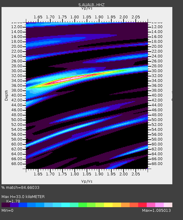
| Estimated Moho Depth: |
33.0 km |
| Estimated Crust Vp/Vs: |
1.78 |
| Assumed Crust Vp: |
6.467 km/s |
| Estimated Crust Vs: |
3.633 km/s |
| Estimated Crust Poisson's Ratio: |
0.27 |
|
| Radial Match: |
84.66033 % |
| Radial Bump: |
313 |
| Transverse Match: |
69.219475 % |
| Transverse Bump: |
400 |
| SOD ConfigId: |
7422571 |
| Insert Time: |
2019-04-21 10:05:36.102 +0000 |
| GWidth: |
2.5 |
| Max Bumps: |
400 |
| Tol: |
0.001 |
|

Signal To Noise
| Channel | StoN | STA | LTA |
| S:AUALB: :HHZ:20151118T18:38:50.429995Z | 1.9624664 | 1.936479E-6 | 9.867579E-7 |
| S:AUALB: :HHN:20151118T18:38:50.429995Z | 1.4731978 | 1.0779022E-6 | 7.316752E-7 |
| S:AUALB: :HHE:20151118T18:38:50.429995Z | 1.2089651 | 9.681904E-7 | 8.008423E-7 |
| Arrivals |
| Ps | 4.2 SECOND |
| PpPs | 13 SECOND |
| PsPs/PpSs | 18 SECOND |


