You are here: Home > Network List > TA - USArray Transportable Network (new EarthScope stations) Stations List
> Station A21K Barrow, AK, USA > Earthquake Result Viewer
A21K Barrow, AK, USA - Earthquake Result Viewer
| Earthquake location: |
Solomon Islands |
| Earthquake latitude/longitude: |
-8.9/158.4 |
| Earthquake time(UTC): |
2015/11/18 (322) 18:31:04 GMT |
| Earthquake Depth: |
11 km |
| Earthquake Magnitude: |
6.8 MWB, 7.0 MI |
| Earthquake Catalog/Contributor: |
NEIC PDE/NEIC COMCAT |
|
| Network: |
TA USArray Transportable Network (new EarthScope stations) |
| Station: |
A21K Barrow, AK, USA |
| Lat/Lon: |
71.32 N/156.62 W |
| Elevation: |
577 m |
|
| Distance: |
85.5 deg |
| Az: |
13.202 deg |
| Baz: |
224.454 deg |
| Ray Param: |
0.044739842 |
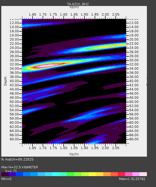
| Estimated Moho Depth: |
32.5 km |
| Estimated Crust Vp/Vs: |
1.71 |
| Assumed Crust Vp: |
6.048 km/s |
| Estimated Crust Vs: |
3.537 km/s |
| Estimated Crust Poisson's Ratio: |
0.24 |
|
| Radial Match: |
89.22825 % |
| Radial Bump: |
349 |
| Transverse Match: |
81.76671 % |
| Transverse Bump: |
400 |
| SOD ConfigId: |
7422571 |
| Insert Time: |
2019-04-21 10:05:50.971 +0000 |
| GWidth: |
2.5 |
| Max Bumps: |
400 |
| Tol: |
0.001 |
|

Signal To Noise
| Channel | StoN | STA | LTA |
| TA:A21K: :BHZ:20151118T18:43:10.250002Z | 9.128333 | 3.0233311E-6 | 3.3120298E-7 |
| TA:A21K: :BHN:20151118T18:43:10.250002Z | 1.4370425 | 9.007704E-7 | 6.268224E-7 |
| TA:A21K: :BHE:20151118T18:43:10.250002Z | 1.6270363 | 6.41508E-7 | 3.9428008E-7 |
| Arrivals |
| Ps | 3.9 SECOND |
| PpPs | 14 SECOND |
| PsPs/PpSs | 18 SECOND |


