You are here: Home > Network List > TA - USArray Transportable Network (new EarthScope stations) Stations List
> Station L27K Beaver Creek, Northway Junction, AK, USA > Earthquake Result Viewer
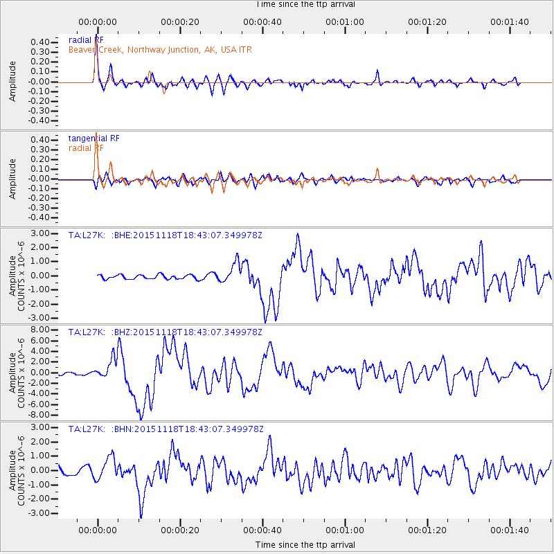
L27K Beaver Creek, Northway Junction, AK, USA - Earthquake Result Viewer
| Earthquake location: |
Solomon Islands |
| Earthquake latitude/longitude: |
-8.9/158.4 |
| Earthquake time(UTC): |
2015/11/18 (322) 18:31:04 GMT |
| Earthquake Depth: |
11 km |
| Earthquake Magnitude: |
6.8 MWB, 7.0 MI |
| Earthquake Catalog/Contributor: |
NEIC PDE/NEIC COMCAT |
|
| Network: |
TA USArray Transportable Network (new EarthScope stations) |
| Station: |
L27K Beaver Creek, Northway Junction, AK, USA |
| Lat/Lon: |
63.06 N/141.83 W |
| Elevation: |
755 m |
|
| Distance: |
84.9 deg |
| Az: |
23.267 deg |
| Baz: |
238.969 deg |
| Ray Param: |
0.04515972 |
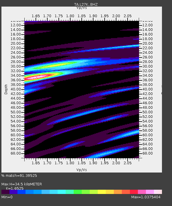
| Estimated Moho Depth: |
34.5 km |
| Estimated Crust Vp/Vs: |
1.65 |
| Assumed Crust Vp: |
6.566 km/s |
| Estimated Crust Vs: |
3.973 km/s |
| Estimated Crust Poisson's Ratio: |
0.21 |
|
| Radial Match: |
91.39525 % |
| Radial Bump: |
400 |
| Transverse Match: |
60.86005 % |
| Transverse Bump: |
400 |
| SOD ConfigId: |
7422571 |
| Insert Time: |
2019-04-21 10:06:10.513 +0000 |
| GWidth: |
2.5 |
| Max Bumps: |
400 |
| Tol: |
0.001 |
|
Signal To Noise
| Channel | StoN | STA | LTA |
| TA:L27K: :BHZ:20151118T18:43:07.349978Z | 7.6258855 | 2.0031487E-6 | 2.6267753E-7 |
| TA:L27K: :BHN:20151118T18:43:07.349978Z | 2.458762 | 8.026547E-7 | 3.2644672E-7 |
| TA:L27K: :BHE:20151118T18:43:07.349978Z | 4.9204507 | 7.3200374E-7 | 1.4876761E-7 |
| Arrivals |
| Ps | 3.5 SECOND |
| PpPs | 14 SECOND |
| PsPs/PpSs | 17 SECOND |


