You are here: Home > Network List > XD14 - Illuminating the architecture of the greater Mount St. Helens magmatic systems f Stations List
> Station MI09 "Mount St Helens, WA" > Earthquake Result Viewer
MI09 "Mount St Helens, WA" - Earthquake Result Viewer
| Earthquake location: |
Solomon Islands |
| Earthquake latitude/longitude: |
-8.9/158.4 |
| Earthquake time(UTC): |
2015/11/18 (322) 18:31:04 GMT |
| Earthquake Depth: |
11 km |
| Earthquake Magnitude: |
6.8 MWB, 7.0 MI |
| Earthquake Catalog/Contributor: |
NEIC PDE/NEIC COMCAT |
|
| Network: |
XD Illuminating the architecture of the greater Mount St. Helens magmatic systems f |
| Station: |
MI09 "Mount St Helens, WA" |
| Lat/Lon: |
46.23 N/121.83 W |
| Elevation: |
1003 m |
|
| Distance: |
89.4 deg |
| Az: |
43.09 deg |
| Baz: |
256.475 deg |
| Ray Param: |
0.041894425 |
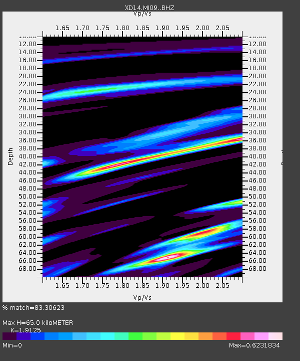
| Estimated Moho Depth: |
65.0 km |
| Estimated Crust Vp/Vs: |
1.91 |
| Assumed Crust Vp: |
6.597 km/s |
| Estimated Crust Vs: |
3.45 km/s |
| Estimated Crust Poisson's Ratio: |
0.31 |
|
| Radial Match: |
83.30623 % |
| Radial Bump: |
380 |
| Transverse Match: |
51.110382 % |
| Transverse Bump: |
400 |
| SOD ConfigId: |
7422571 |
| Insert Time: |
2019-04-21 10:08:01.651 +0000 |
| GWidth: |
2.5 |
| Max Bumps: |
400 |
| Tol: |
0.001 |
|

Signal To Noise
| Channel | StoN | STA | LTA |
| XD:MI09: :BHZ:20151118T18:43:29.109988Z | 3.395252 | 1.7371185E-6 | 5.116317E-7 |
| XD:MI09: :BHN:20151118T18:43:29.109988Z | 1.6635824 | 8.016766E-7 | 4.8189776E-7 |
| XD:MI09: :BHE:20151118T18:43:29.109988Z | 2.1270251 | 7.115267E-7 | 3.345173E-7 |
| Arrivals |
| Ps | 9.2 SECOND |
| PpPs | 28 SECOND |
| PsPs/PpSs | 37 SECOND |


