You are here: Home > Network List > CI - Caltech Regional Seismic Network Stations List
> Station PAS Pasadena, California, USA > Earthquake Result Viewer
PAS Pasadena, California, USA - Earthquake Result Viewer
| Earthquake location: |
Guatemala |
| Earthquake latitude/longitude: |
14.4/-91.5 |
| Earthquake time(UTC): |
1998/03/03 (062) 02:24:43 GMT |
| Earthquake Depth: |
63 km |
| Earthquake Magnitude: |
5.5 MB, 5.4 MS, 6.2 UNKNOWN, 6.1 MW |
| Earthquake Catalog/Contributor: |
WHDF/NEIC |
|
| Network: |
CI Caltech Regional Seismic Network |
| Station: |
PAS Pasadena, California, USA |
| Lat/Lon: |
34.15 N/118.17 W |
| Elevation: |
257 m |
|
| Distance: |
31.1 deg |
| Az: |
313.898 deg |
| Baz: |
122.65 deg |
| Ray Param: |
0.07905638 |
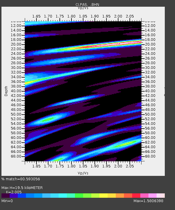
| Estimated Moho Depth: |
19.5 km |
| Estimated Crust Vp/Vs: |
2.01 |
| Assumed Crust Vp: |
6.1 km/s |
| Estimated Crust Vs: |
3.042 km/s |
| Estimated Crust Poisson's Ratio: |
0.33 |
|
| Radial Match: |
80.593056 % |
| Radial Bump: |
371 |
| Transverse Match: |
86.88458 % |
| Transverse Bump: |
400 |
| SOD ConfigId: |
4770 |
| Insert Time: |
2010-02-25 23:56:43.839 +0000 |
| GWidth: |
2.5 |
| Max Bumps: |
400 |
| Tol: |
0.001 |
|

Signal To Noise
| Channel | StoN | STA | LTA |
| CI:PAS: :BHN:19980303T02:30:26.391003Z | 0.88960147 | 1.6466336E-7 | 1.8509789E-7 |
| CI:PAS: :BHE:19980303T02:30:26.391003Z | 1.0676038 | 3.838789E-7 | 3.5957055E-7 |
| CI:PAS: :BHZ:19980303T02:30:26.391003Z | 1.469912 | 4.9446396E-7 | 3.3639017E-7 |
| Arrivals |
| Ps | 3.4 SECOND |
| PpPs | 9.0 SECOND |
| PsPs/PpSs | 12 SECOND |


