You are here: Home > Network List > YE11 - Testing TA and FA Vaults and Directly Buried Sensors (3T) Stations List
> Station SPOL2 South Pole, Antarctica > Earthquake Result Viewer
SPOL2 South Pole, Antarctica - Earthquake Result Viewer
| Earthquake location: |
Solomon Islands |
| Earthquake latitude/longitude: |
-8.9/158.4 |
| Earthquake time(UTC): |
2015/11/18 (322) 18:31:04 GMT |
| Earthquake Depth: |
11 km |
| Earthquake Magnitude: |
6.8 MWB, 7.0 MI |
| Earthquake Catalog/Contributor: |
NEIC PDE/NEIC COMCAT |
|
| Network: |
YE Testing TA and FA Vaults and Directly Buried Sensors (3T) |
| Station: |
SPOL2 South Pole, Antarctica |
| Lat/Lon: |
89.93 S/144.44 E |
| Elevation: |
2850 m |
|
| Distance: |
81.0 deg |
| Az: |
180.017 deg |
| Baz: |
13.983 deg |
| Ray Param: |
0.0478618 |
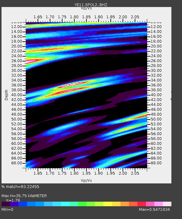
| Estimated Moho Depth: |
35.75 km |
| Estimated Crust Vp/Vs: |
1.78 |
| Assumed Crust Vp: |
6.193 km/s |
| Estimated Crust Vs: |
3.479 km/s |
| Estimated Crust Poisson's Ratio: |
0.27 |
|
| Radial Match: |
93.22455 % |
| Radial Bump: |
400 |
| Transverse Match: |
88.825905 % |
| Transverse Bump: |
400 |
| SOD ConfigId: |
7422571 |
| Insert Time: |
2019-04-21 10:09:28.353 +0000 |
| GWidth: |
2.5 |
| Max Bumps: |
400 |
| Tol: |
0.001 |
|

Signal To Noise
| Channel | StoN | STA | LTA |
| YE:SPOL2: :BHZ:20151118T18:42:48.000002Z | 14.396591 | 3.2008538E-6 | 2.2233415E-7 |
| YE:SPOL2: :BH1:20151118T18:42:48.000002Z | 4.0412936 | 8.0680303E-7 | 1.9963981E-7 |
| YE:SPOL2: :BH2:20151118T18:42:48.000002Z | 1.8536618 | 2.5972875E-7 | 1.4011657E-7 |
| Arrivals |
| Ps | 4.6 SECOND |
| PpPs | 16 SECOND |
| PsPs/PpSs | 20 SECOND |


