You are here: Home > Network List > YN10 - San Jacinto Fault Zone Stations List
> Station JFS1 JFS1 > Earthquake Result Viewer
JFS1 JFS1 - Earthquake Result Viewer
| Earthquake location: |
Solomon Islands |
| Earthquake latitude/longitude: |
-8.9/158.4 |
| Earthquake time(UTC): |
2015/11/18 (322) 18:31:04 GMT |
| Earthquake Depth: |
11 km |
| Earthquake Magnitude: |
6.8 MWB, 7.0 MI |
| Earthquake Catalog/Contributor: |
NEIC PDE/NEIC COMCAT |
|
| Network: |
YN San Jacinto Fault Zone |
| Station: |
JFS1 JFS1 |
| Lat/Lon: |
33.42 N/116.40 W |
| Elevation: |
648 m |
|
| Distance: |
90.9 deg |
| Az: |
56.455 deg |
| Baz: |
259.935 deg |
| Ray Param: |
0.04164226 |
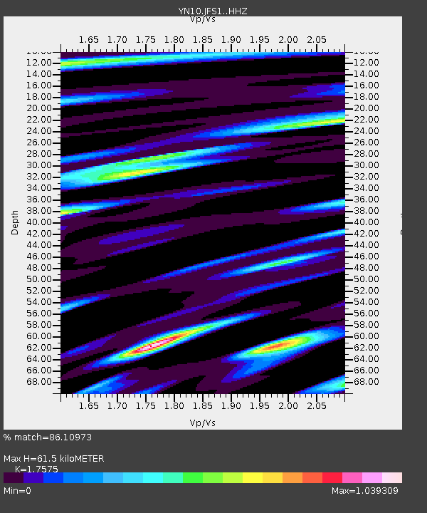
| Estimated Moho Depth: |
61.5 km |
| Estimated Crust Vp/Vs: |
1.76 |
| Assumed Crust Vp: |
6.264 km/s |
| Estimated Crust Vs: |
3.564 km/s |
| Estimated Crust Poisson's Ratio: |
0.26 |
|
| Radial Match: |
86.10973 % |
| Radial Bump: |
400 |
| Transverse Match: |
65.21897 % |
| Transverse Bump: |
400 |
| SOD ConfigId: |
7422571 |
| Insert Time: |
2019-04-21 10:09:33.430 +0000 |
| GWidth: |
2.5 |
| Max Bumps: |
400 |
| Tol: |
0.001 |
|

Signal To Noise
| Channel | StoN | STA | LTA |
| YN:JFS1: :HHZ:20151118T18:43:36.068972Z | 3.8476095 | 1.058915E-6 | 2.7521375E-7 |
| YN:JFS1: :HHN:20151118T18:43:36.068972Z | 0.8660917 | 3.3992723E-7 | 3.924841E-7 |
| YN:JFS1: :HHE:20151118T18:43:36.068972Z | 0.755823 | 3.4685434E-7 | 4.5890945E-7 |
| Arrivals |
| Ps | 7.6 SECOND |
| PpPs | 27 SECOND |
| PsPs/PpSs | 34 SECOND |


