You are here: Home > Network List > YT07 - POLENET Stations List
> Station P061 P061 > Earthquake Result Viewer
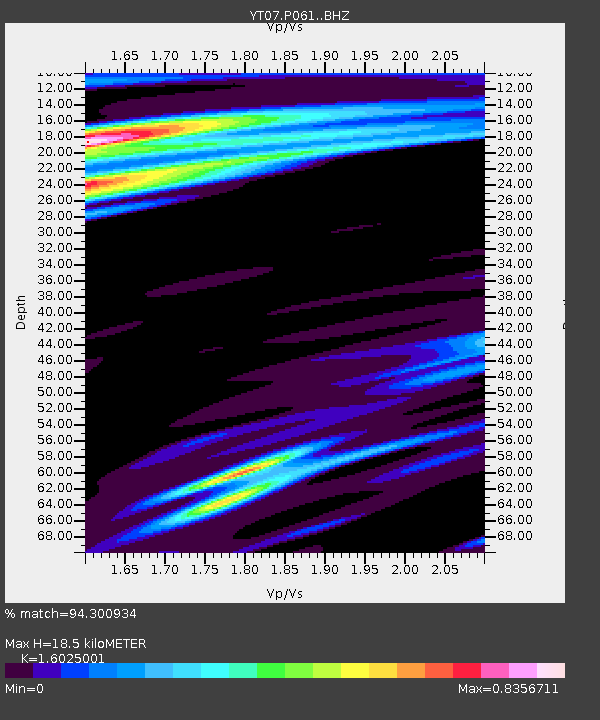
P061 P061 - Earthquake Result Viewer
| Earthquake location: |
Solomon Islands |
| Earthquake latitude/longitude: |
-8.9/158.4 |
| Earthquake time(UTC): |
2015/11/18 (322) 18:31:04 GMT |
| Earthquake Depth: |
11 km |
| Earthquake Magnitude: |
6.8 MWB, 7.0 MI |
| Earthquake Catalog/Contributor: |
NEIC PDE/NEIC COMCAT |
|
| Network: |
YT POLENET |
| Station: |
P061 P061 |
| Lat/Lon: |
84.50 S/77.22 E |
| Elevation: |
1758 m |
|
| Distance: |
80.3 deg |
| Az: |
185.551 deg |
| Baz: |
82.093 deg |
| Ray Param: |
0.0483642 |
| Estimated Moho Depth: |
18.5 km |
| Estimated Crust Vp/Vs: |
1.60 |
| Assumed Crust Vp: |
6.261 km/s |
| Estimated Crust Vs: |
3.907 km/s |
| Estimated Crust Poisson's Ratio: |
0.18 |
|
| Radial Match: |
94.300934 % |
| Radial Bump: |
400 |
| Transverse Match: |
79.81797 % |
| Transverse Bump: |
400 |
| SOD ConfigId: |
7422571 |
| Insert Time: |
2019-04-21 10:10:02.135 +0000 |
| GWidth: |
2.5 |
| Max Bumps: |
400 |
| Tol: |
0.001 |
|

Signal To Noise
| Channel | StoN | STA | LTA |
| YT:P061: :BHZ:20151118T18:42:44.075015Z | 9.226069 | 2.0644743E-6 | 2.2376531E-7 |
| YT:P061: :BHN:20151118T18:42:44.075015Z | 1.8431517 | 4.541527E-7 | 2.4640008E-7 |
| YT:P061: :BHE:20151118T18:42:44.075015Z | 2.788023 | 8.249836E-7 | 2.9590274E-7 |
| Arrivals |
| Ps | 1.8 SECOND |
| PpPs | 7.5 SECOND |
| PsPs/PpSs | 9.3 SECOND |


