You are here: Home > Network List > CI - Caltech Regional Seismic Network Stations List
> Station TUQ Turquiose Mountain, Baker, CA, USA > Earthquake Result Viewer
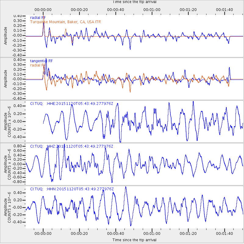
TUQ Turquiose Mountain, Baker, CA, USA - Earthquake Result Viewer
*The percent match for this event was below the threshold and hence no stack was calculated.
| Earthquake location: |
Bonin Islands, Japan Region |
| Earthquake latitude/longitude: |
26.4/142.7 |
| Earthquake time(UTC): |
2015/11/20 (324) 05:31:52 GMT |
| Earthquake Depth: |
13 km |
| Earthquake Magnitude: |
5.5 MB |
| Earthquake Catalog/Contributor: |
NEIC PDE/NEIC COMCAT |
|
| Network: |
CI Caltech Regional Seismic Network |
| Station: |
TUQ Turquiose Mountain, Baker, CA, USA |
| Lat/Lon: |
35.44 N/115.92 W |
| Elevation: |
1350 m |
|
| Distance: |
83.6 deg |
| Az: |
53.66 deg |
| Baz: |
297.763 deg |
| Ray Param: |
$rayparam |
*The percent match for this event was below the threshold and hence was not used in the summary stack. |
|
| Radial Match: |
65.57126 % |
| Radial Bump: |
400 |
| Transverse Match: |
72.0688 % |
| Transverse Bump: |
400 |
| SOD ConfigId: |
7422571 |
| Insert Time: |
2019-04-21 10:12:53.495 +0000 |
| GWidth: |
2.5 |
| Max Bumps: |
400 |
| Tol: |
0.001 |
|
Signal To Noise
| Channel | StoN | STA | LTA |
| CI:TUQ: :HHZ:20151120T05:43:49.277976Z | 3.0027666 | 5.1878703E-7 | 1.7276969E-7 |
| CI:TUQ: :HHN:20151120T05:43:49.277976Z | 1.082478 | 1.5787738E-7 | 1.4584812E-7 |
| CI:TUQ: :HHE:20151120T05:43:49.277976Z | 1.07442 | 2.2894822E-7 | 2.1309006E-7 |
| Arrivals |
| Ps | |
| PpPs | |
| PsPs/PpSs | |


