You are here: Home > Network List > CN - Canadian National Seismograph Network Stations List
> Station INK INUVIK, NT > Earthquake Result Viewer
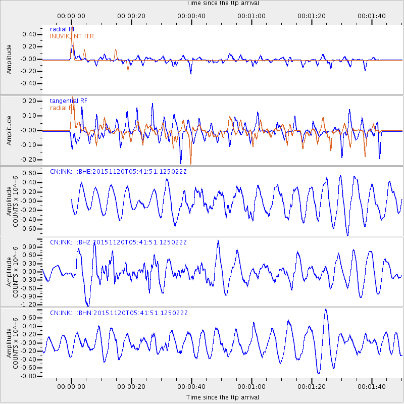
INK INUVIK, NT - Earthquake Result Viewer
*The percent match for this event was below the threshold and hence no stack was calculated.
| Earthquake location: |
Bonin Islands, Japan Region |
| Earthquake latitude/longitude: |
26.4/142.7 |
| Earthquake time(UTC): |
2015/11/20 (324) 05:31:52 GMT |
| Earthquake Depth: |
13 km |
| Earthquake Magnitude: |
5.5 MB |
| Earthquake Catalog/Contributor: |
NEIC PDE/NEIC COMCAT |
|
| Network: |
CN Canadian National Seismograph Network |
| Station: |
INK INUVIK, NT |
| Lat/Lon: |
68.31 N/133.53 W |
| Elevation: |
44 m |
|
| Distance: |
63.5 deg |
| Az: |
24.396 deg |
| Baz: |
274.738 deg |
| Ray Param: |
$rayparam |
*The percent match for this event was below the threshold and hence was not used in the summary stack. |
|
| Radial Match: |
56.518364 % |
| Radial Bump: |
348 |
| Transverse Match: |
62.427563 % |
| Transverse Bump: |
362 |
| SOD ConfigId: |
7422571 |
| Insert Time: |
2019-04-21 10:13:03.926 +0000 |
| GWidth: |
2.5 |
| Max Bumps: |
400 |
| Tol: |
0.001 |
|
Signal To Noise
| Channel | StoN | STA | LTA |
| CN:INK: :BHZ:20151120T05:41:51.125022Z | 2.2867215 | 4.886594E-7 | 2.1369434E-7 |
| CN:INK: :BHN:20151120T05:41:51.125022Z | 1.2142935 | 1.8800232E-7 | 1.5482445E-7 |
| CN:INK: :BHE:20151120T05:41:51.125022Z | 1.4846433 | 3.1299703E-7 | 2.1082305E-7 |
| Arrivals |
| Ps | |
| PpPs | |
| PsPs/PpSs | |


