You are here: Home > Network List > TJ - Tajikistan National Seismic Network Stations List
> Station GARM Garm, Tajikistan > Earthquake Result Viewer
GARM Garm, Tajikistan - Earthquake Result Viewer
*The percent match for this event was below the threshold and hence no stack was calculated.
| Earthquake location: |
Bonin Islands, Japan Region |
| Earthquake latitude/longitude: |
26.4/142.7 |
| Earthquake time(UTC): |
2015/11/20 (324) 05:31:52 GMT |
| Earthquake Depth: |
13 km |
| Earthquake Magnitude: |
5.5 MB |
| Earthquake Catalog/Contributor: |
NEIC PDE/NEIC COMCAT |
|
| Network: |
TJ Tajikistan National Seismic Network |
| Station: |
GARM Garm, Tajikistan |
| Lat/Lon: |
39.00 N/70.32 E |
| Elevation: |
1305 m |
|
| Distance: |
60.8 deg |
| Az: |
301.665 deg |
| Baz: |
78.481 deg |
| Ray Param: |
$rayparam |
*The percent match for this event was below the threshold and hence was not used in the summary stack. |
|
| Radial Match: |
76.11747 % |
| Radial Bump: |
400 |
| Transverse Match: |
80.713135 % |
| Transverse Bump: |
400 |
| SOD ConfigId: |
7422571 |
| Insert Time: |
2019-04-21 10:16:50.042 +0000 |
| GWidth: |
2.5 |
| Max Bumps: |
400 |
| Tol: |
0.001 |
|
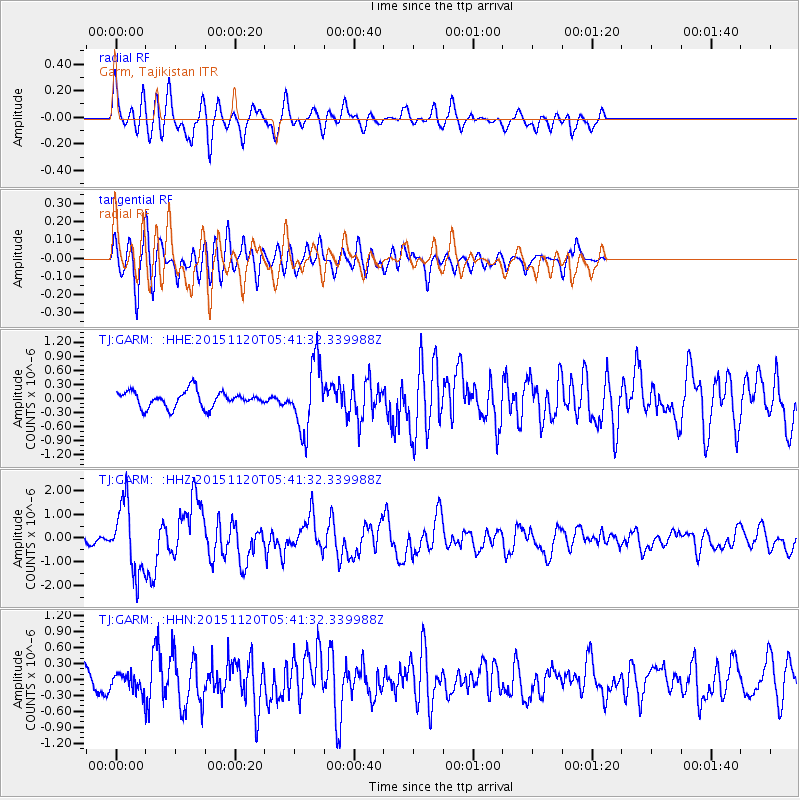
Signal To Noise
| Channel | StoN | STA | LTA |
| TJ:GARM: :HHZ:20151120T05:41:32.339988Z | 12.032048 | 1.4661618E-6 | 1.2185473E-7 |
| TJ:GARM: :HHN:20151120T05:41:32.339988Z | 1.1148077 | 2.0176832E-7 | 1.8098935E-7 |
| TJ:GARM: :HHE:20151120T05:41:32.339988Z | 4.138841 | 7.1213054E-7 | 1.7206037E-7 |
| Arrivals |
| Ps | |
| PpPs | |
| PsPs/PpSs | |


