You are here: Home > Network List > XQ15 - Rapid response to the Mw 7.9 earthquake of April 25, 2015 in Nepal Stations List
> Station NA020 Katmandu,Nepal > Earthquake Result Viewer
NA020 Katmandu,Nepal - Earthquake Result Viewer
| Earthquake location: |
Bonin Islands, Japan Region |
| Earthquake latitude/longitude: |
26.4/142.7 |
| Earthquake time(UTC): |
2015/11/20 (324) 05:31:52 GMT |
| Earthquake Depth: |
13 km |
| Earthquake Magnitude: |
5.5 MB |
| Earthquake Catalog/Contributor: |
NEIC PDE/NEIC COMCAT |
|
| Network: |
XQ Rapid response to the Mw 7.9 earthquake of April 25, 2015 in Nepal |
| Station: |
NA020 Katmandu,Nepal |
| Lat/Lon: |
27.91 N/85.05 E |
| Elevation: |
1107 m |
|
| Distance: |
50.9 deg |
| Az: |
285.581 deg |
| Baz: |
77.532 deg |
| Ray Param: |
0.06773794 |
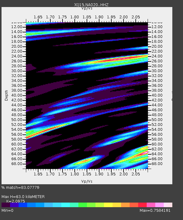
| Estimated Moho Depth: |
63.0 km |
| Estimated Crust Vp/Vs: |
2.10 |
| Assumed Crust Vp: |
6.142 km/s |
| Estimated Crust Vs: |
2.928 km/s |
| Estimated Crust Poisson's Ratio: |
0.35 |
|
| Radial Match: |
83.07779 % |
| Radial Bump: |
400 |
| Transverse Match: |
71.09858 % |
| Transverse Bump: |
400 |
| SOD ConfigId: |
7422571 |
| Insert Time: |
2019-04-21 10:18:22.573 +0000 |
| GWidth: |
2.5 |
| Max Bumps: |
400 |
| Tol: |
0.001 |
|

Signal To Noise
| Channel | StoN | STA | LTA |
| XQ:NA020: :HHZ:20151120T05:40:21.730002Z | 6.2479563 | 1.0193943E-6 | 1.6315644E-7 |
| XQ:NA020: :HH1:20151120T05:40:21.730002Z | 1.2999403 | 1.1482642E-7 | 8.833207E-8 |
| XQ:NA020: :HH2:20151120T05:40:21.730002Z | 2.6545236 | 5.590806E-7 | 2.1061429E-7 |
| Arrivals |
| Ps | 12 SECOND |
| PpPs | 30 SECOND |
| PsPs/PpSs | 42 SECOND |


