You are here: Home > Network List > XQ15 - Rapid response to the Mw 7.9 earthquake of April 25, 2015 in Nepal Stations List
> Station NA390 Katmandu,Nepal > Earthquake Result Viewer
NA390 Katmandu,Nepal - Earthquake Result Viewer
| Earthquake location: |
Bonin Islands, Japan Region |
| Earthquake latitude/longitude: |
26.4/142.7 |
| Earthquake time(UTC): |
2015/11/20 (324) 05:31:52 GMT |
| Earthquake Depth: |
13 km |
| Earthquake Magnitude: |
5.5 MB |
| Earthquake Catalog/Contributor: |
NEIC PDE/NEIC COMCAT |
|
| Network: |
XQ Rapid response to the Mw 7.9 earthquake of April 25, 2015 in Nepal |
| Station: |
NA390 Katmandu,Nepal |
| Lat/Lon: |
27.43 N/84.39 E |
| Elevation: |
205 m |
|
| Distance: |
51.6 deg |
| Az: |
285.149 deg |
| Baz: |
76.956 deg |
| Ray Param: |
0.06731043 |
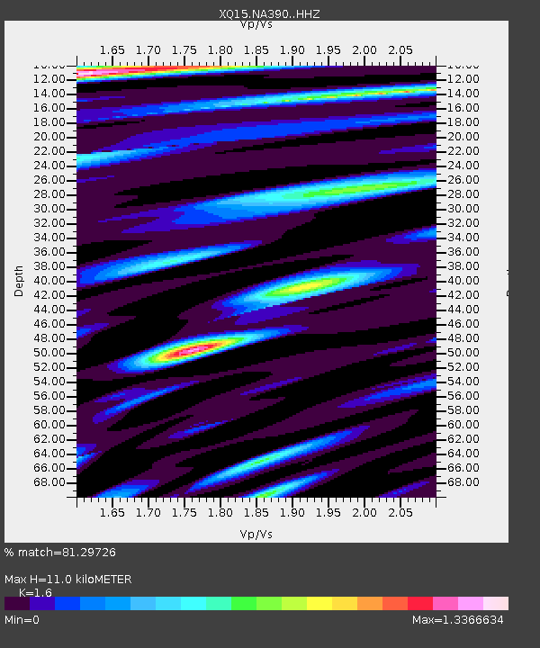
| Estimated Moho Depth: |
11.0 km |
| Estimated Crust Vp/Vs: |
1.60 |
| Assumed Crust Vp: |
6.142 km/s |
| Estimated Crust Vs: |
3.839 km/s |
| Estimated Crust Poisson's Ratio: |
0.18 |
|
| Radial Match: |
81.29726 % |
| Radial Bump: |
400 |
| Transverse Match: |
81.29722 % |
| Transverse Bump: |
400 |
| SOD ConfigId: |
7422571 |
| Insert Time: |
2019-04-21 10:18:32.009 +0000 |
| GWidth: |
2.5 |
| Max Bumps: |
400 |
| Tol: |
0.001 |
|

Signal To Noise
| Channel | StoN | STA | LTA |
| XQ:NA390: :HHZ:20151120T05:40:26.805015Z | 8.69019 | 1.3122519E-6 | 1.5100382E-7 |
| $trig.getChannelId() | $trig.getValue() | $trig.getSTA() | $trig.getLTA() |
| XQ:NA390: :HH2:20151120T05:40:26.805015Z | 2.8460824 | 4.896712E-7 | 1.7205095E-7 |
| Arrivals |
| Ps | 1.1 SECOND |
| PpPs | 4.4 SECOND |
| PsPs/PpSs | 5.5 SECOND |


