You are here: Home > Network List > IU - Global Seismograph Network (GSN - IRIS/USGS) Stations List
> Station PMG Port Moresby, New Guinea > Earthquake Result Viewer
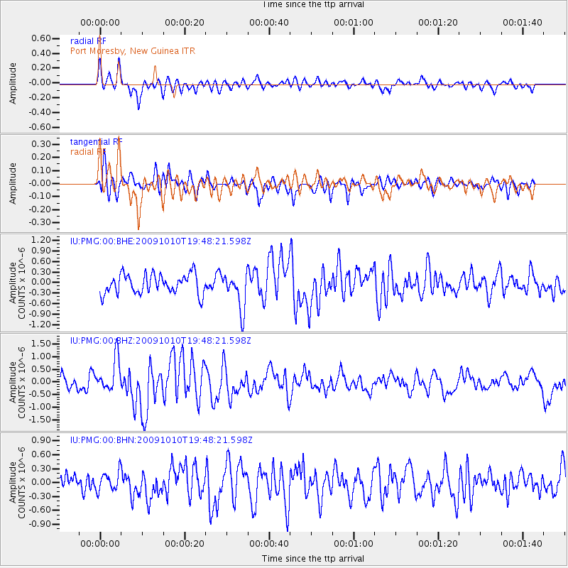
PMG Port Moresby, New Guinea - Earthquake Result Viewer
*The percent match for this event was below the threshold and hence no stack was calculated.
| Earthquake location: |
Tonga Islands |
| Earthquake latitude/longitude: |
-15.7/-173.1 |
| Earthquake time(UTC): |
2009/10/10 (283) 19:41:23 GMT |
| Earthquake Depth: |
12 km |
| Earthquake Magnitude: |
5.6 MB, 5.7 MS, 5.9 MW, 5.9 MW |
| Earthquake Catalog/Contributor: |
WHDF/NEIC |
|
| Network: |
IU Global Seismograph Network (GSN - IRIS/USGS) |
| Station: |
PMG Port Moresby, New Guinea |
| Lat/Lon: |
9.40 S/147.16 E |
| Elevation: |
90 m |
|
| Distance: |
39.3 deg |
| Az: |
274.261 deg |
| Baz: |
103.194 deg |
| Ray Param: |
$rayparam |
*The percent match for this event was below the threshold and hence was not used in the summary stack. |
|
| Radial Match: |
74.027084 % |
| Radial Bump: |
400 |
| Transverse Match: |
59.39322 % |
| Transverse Bump: |
400 |
| SOD ConfigId: |
1 |
| Insert Time: |
2010-02-19 00:40:36.782 +0000 |
| GWidth: |
2.5 |
| Max Bumps: |
400 |
| Tol: |
0.001 |
|
Signal To Noise
| Channel | StoN | STA | LTA |
| IU:PMG:00:BHZ:20091010T19:48:21.598Z | 2.5749779 | 6.75067E-7 | 2.621642E-7 |
| IU:PMG:00:BHN:20091010T19:48:21.598Z | 0.9660808 | 2.1084179E-7 | 2.1824447E-7 |
| IU:PMG:00:BHE:20091010T19:48:21.598Z | 1.95221 | 5.4337966E-7 | 2.783408E-7 |
| Arrivals |
| Ps | |
| PpPs | |
| PsPs/PpSs | |


