You are here: Home > Network List > TA - USArray Transportable Network (new EarthScope stations) Stations List
> Station A21K Barrow, AK, USA > Earthquake Result Viewer
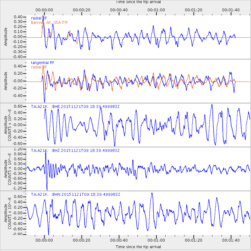
A21K Barrow, AK, USA - Earthquake Result Viewer
*The percent match for this event was below the threshold and hence no stack was calculated.
| Earthquake location: |
Banda Sea |
| Earthquake latitude/longitude: |
-7.2/129.9 |
| Earthquake time(UTC): |
2015/11/21 (325) 09:06:12 GMT |
| Earthquake Depth: |
67 km |
| Earthquake Magnitude: |
6.1 MWP |
| Earthquake Catalog/Contributor: |
NEIC PDE/NEIC COMCAT |
|
| Network: |
TA USArray Transportable Network (new EarthScope stations) |
| Station: |
A21K Barrow, AK, USA |
| Lat/Lon: |
71.32 N/156.62 W |
| Elevation: |
577 m |
|
| Distance: |
91.5 deg |
| Az: |
17.997 deg |
| Baz: |
252.079 deg |
| Ray Param: |
$rayparam |
*The percent match for this event was below the threshold and hence was not used in the summary stack. |
|
| Radial Match: |
39.4961 % |
| Radial Bump: |
324 |
| Transverse Match: |
56.2778 % |
| Transverse Bump: |
342 |
| SOD ConfigId: |
7422571 |
| Insert Time: |
2019-04-21 10:21:43.291 +0000 |
| GWidth: |
2.5 |
| Max Bumps: |
400 |
| Tol: |
0.001 |
|
Signal To Noise
| Channel | StoN | STA | LTA |
| TA:A21K: :BHZ:20151121T09:18:39.499983Z | 3.225267 | 5.0605E-7 | 1.5690173E-7 |
| TA:A21K: :BHN:20151121T09:18:39.499983Z | 1.8704606 | 3.6670355E-7 | 1.9604987E-7 |
| TA:A21K: :BHE:20151121T09:18:39.499983Z | 1.1621124 | 3.103013E-7 | 2.6701485E-7 |
| Arrivals |
| Ps | |
| PpPs | |
| PsPs/PpSs | |


