You are here: Home > Network List > TA - USArray Transportable Network (new EarthScope stations) Stations List
> Station J26L Joseph Creek, AK, USA > Earthquake Result Viewer
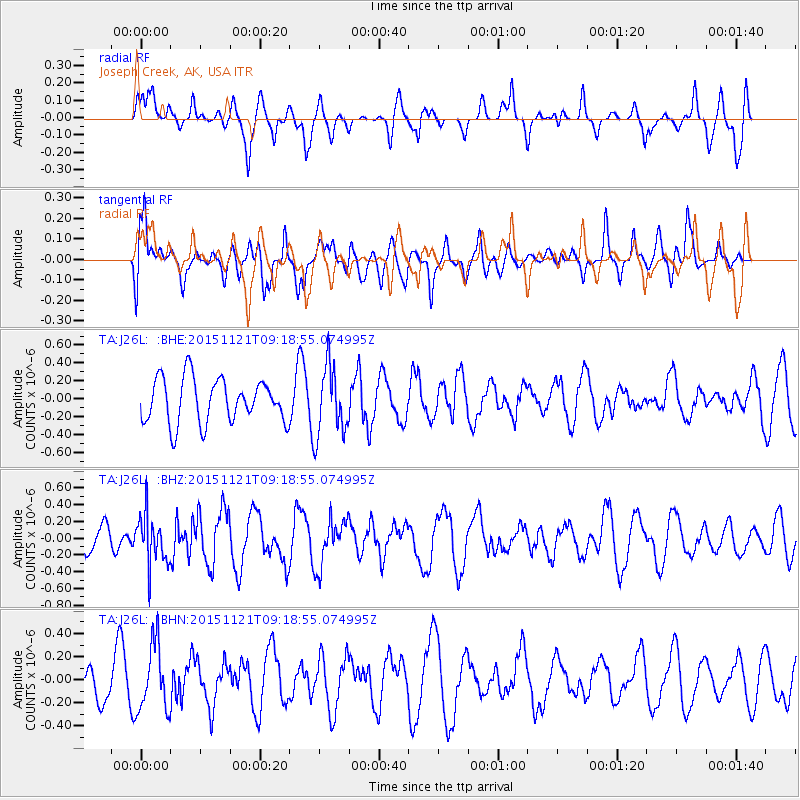
J26L Joseph Creek, AK, USA - Earthquake Result Viewer
*The percent match for this event was below the threshold and hence no stack was calculated.
| Earthquake location: |
Banda Sea |
| Earthquake latitude/longitude: |
-7.2/129.9 |
| Earthquake time(UTC): |
2015/11/21 (325) 09:06:12 GMT |
| Earthquake Depth: |
67 km |
| Earthquake Magnitude: |
6.1 MWP |
| Earthquake Catalog/Contributor: |
NEIC PDE/NEIC COMCAT |
|
| Network: |
TA USArray Transportable Network (new EarthScope stations) |
| Station: |
J26L Joseph Creek, AK, USA |
| Lat/Lon: |
64.50 N/143.56 W |
| Elevation: |
1144 m |
|
| Distance: |
94.9 deg |
| Az: |
25.7 deg |
| Baz: |
263.755 deg |
| Ray Param: |
$rayparam |
*The percent match for this event was below the threshold and hence was not used in the summary stack. |
|
| Radial Match: |
56.91505 % |
| Radial Bump: |
378 |
| Transverse Match: |
56.870304 % |
| Transverse Bump: |
400 |
| SOD ConfigId: |
7422571 |
| Insert Time: |
2019-04-21 10:21:46.523 +0000 |
| GWidth: |
2.5 |
| Max Bumps: |
400 |
| Tol: |
0.001 |
|
Signal To Noise
| Channel | StoN | STA | LTA |
| TA:J26L: :BHZ:20151121T09:18:55.074995Z | 1.7710747 | 2.9026913E-7 | 1.6389434E-7 |
| TA:J26L: :BHN:20151121T09:18:55.074995Z | 1.3260224 | 2.8530843E-7 | 2.1516111E-7 |
| TA:J26L: :BHE:20151121T09:18:55.074995Z | 1.3905545 | 3.443725E-7 | 2.476512E-7 |
| Arrivals |
| Ps | |
| PpPs | |
| PsPs/PpSs | |


