You are here: Home > Network List > TJ - Tajikistan National Seismic Network Stations List
> Station GARM Garm, Tajikistan > Earthquake Result Viewer
GARM Garm, Tajikistan - Earthquake Result Viewer
| Earthquake location: |
Banda Sea |
| Earthquake latitude/longitude: |
-7.2/129.9 |
| Earthquake time(UTC): |
2015/11/21 (325) 09:06:12 GMT |
| Earthquake Depth: |
67 km |
| Earthquake Magnitude: |
6.1 MWP |
| Earthquake Catalog/Contributor: |
NEIC PDE/NEIC COMCAT |
|
| Network: |
TJ Tajikistan National Seismic Network |
| Station: |
GARM Garm, Tajikistan |
| Lat/Lon: |
39.00 N/70.32 E |
| Elevation: |
1305 m |
|
| Distance: |
71.8 deg |
| Az: |
314.952 deg |
| Baz: |
115.69 deg |
| Ray Param: |
0.053964343 |
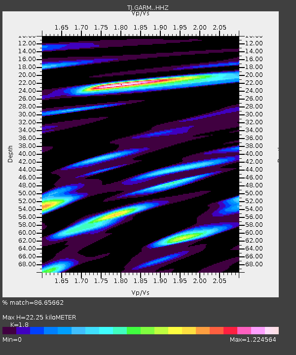
| Estimated Moho Depth: |
22.25 km |
| Estimated Crust Vp/Vs: |
1.80 |
| Assumed Crust Vp: |
6.306 km/s |
| Estimated Crust Vs: |
3.503 km/s |
| Estimated Crust Poisson's Ratio: |
0.28 |
|
| Radial Match: |
86.65662 % |
| Radial Bump: |
400 |
| Transverse Match: |
73.91253 % |
| Transverse Bump: |
400 |
| SOD ConfigId: |
7422571 |
| Insert Time: |
2019-04-21 10:21:58.862 +0000 |
| GWidth: |
2.5 |
| Max Bumps: |
400 |
| Tol: |
0.001 |
|
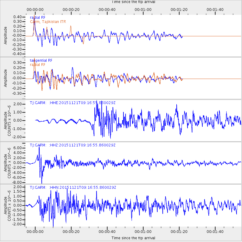
Signal To Noise
| Channel | StoN | STA | LTA |
| TJ:GARM: :HHZ:20151121T09:16:55.860029Z | 29.397552 | 3.2686728E-6 | 1.11188605E-7 |
| TJ:GARM: :HHN:20151121T09:16:55.860029Z | 6.0130887 | 6.305176E-7 | 1.0485752E-7 |
| TJ:GARM: :HHE:20151121T09:16:55.860029Z | 7.112941 | 9.605407E-7 | 1.3504129E-7 |
| Arrivals |
| Ps | 2.9 SECOND |
| PpPs | 9.6 SECOND |
| PsPs/PpSs | 12 SECOND |


