You are here: Home > Network List > TJ - Tajikistan National Seismic Network Stations List
> Station MANEM Manem, Tajikistan > Earthquake Result Viewer
MANEM Manem, Tajikistan - Earthquake Result Viewer
| Earthquake location: |
Banda Sea |
| Earthquake latitude/longitude: |
-7.2/129.9 |
| Earthquake time(UTC): |
2015/11/21 (325) 09:06:12 GMT |
| Earthquake Depth: |
67 km |
| Earthquake Magnitude: |
6.1 MWP |
| Earthquake Catalog/Contributor: |
NEIC PDE/NEIC COMCAT |
|
| Network: |
TJ Tajikistan National Seismic Network |
| Station: |
MANEM Manem, Tajikistan |
| Lat/Lon: |
37.53 N/71.66 E |
| Elevation: |
2312 m |
|
| Distance: |
70.2 deg |
| Az: |
314.046 deg |
| Baz: |
116.223 deg |
| Ray Param: |
0.055012126 |
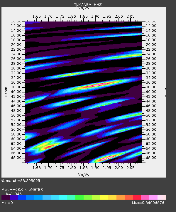
| Estimated Moho Depth: |
68.0 km |
| Estimated Crust Vp/Vs: |
1.95 |
| Assumed Crust Vp: |
6.306 km/s |
| Estimated Crust Vs: |
3.242 km/s |
| Estimated Crust Poisson's Ratio: |
0.32 |
|
| Radial Match: |
85.399925 % |
| Radial Bump: |
400 |
| Transverse Match: |
77.37412 % |
| Transverse Bump: |
400 |
| SOD ConfigId: |
7422571 |
| Insert Time: |
2019-04-21 10:22:00.193 +0000 |
| GWidth: |
2.5 |
| Max Bumps: |
400 |
| Tol: |
0.001 |
|

Signal To Noise
| Channel | StoN | STA | LTA |
| TJ:MANEM: :HHZ:20151121T09:16:46.249983Z | 18.36172 | 2.5076113E-6 | 1.3656734E-7 |
| TJ:MANEM: :HHN:20151121T09:16:46.249983Z | 2.2335942 | 4.0144369E-7 | 1.7972991E-7 |
| TJ:MANEM: :HHE:20151121T09:16:46.249983Z | 4.448167 | 7.702375E-7 | 1.7315843E-7 |
| Arrivals |
| Ps | 11 SECOND |
| PpPs | 31 SECOND |
| PsPs/PpSs | 41 SECOND |


