You are here: Home > Network List > YT07 - POLENET Stations List
> Station CLRK CLRK > Earthquake Result Viewer
CLRK CLRK - Earthquake Result Viewer
| Earthquake location: |
Banda Sea |
| Earthquake latitude/longitude: |
-7.2/129.9 |
| Earthquake time(UTC): |
2015/11/21 (325) 09:06:12 GMT |
| Earthquake Depth: |
67 km |
| Earthquake Magnitude: |
6.1 MWP |
| Earthquake Catalog/Contributor: |
NEIC PDE/NEIC COMCAT |
|
| Network: |
YT POLENET |
| Station: |
CLRK CLRK |
| Lat/Lon: |
77.32 S/141.85 W |
| Elevation: |
1043 m |
|
| Distance: |
82.6 deg |
| Az: |
167.139 deg |
| Baz: |
270.14 deg |
| Ray Param: |
0.046625417 |
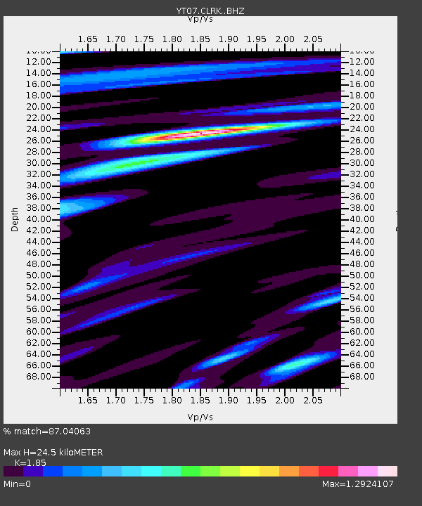
| Estimated Moho Depth: |
24.5 km |
| Estimated Crust Vp/Vs: |
1.85 |
| Assumed Crust Vp: |
6.182 km/s |
| Estimated Crust Vs: |
3.341 km/s |
| Estimated Crust Poisson's Ratio: |
0.29 |
|
| Radial Match: |
87.04063 % |
| Radial Bump: |
400 |
| Transverse Match: |
75.08114 % |
| Transverse Bump: |
400 |
| SOD ConfigId: |
7422571 |
| Insert Time: |
2019-04-21 10:23:31.809 +0000 |
| GWidth: |
2.5 |
| Max Bumps: |
400 |
| Tol: |
0.001 |
|

Signal To Noise
| Channel | StoN | STA | LTA |
| YT:CLRK: :BHZ:20151121T09:17:56.924971Z | 8.737085 | 7.9374E-7 | 9.084723E-8 |
| YT:CLRK: :BHN:20151121T09:17:56.924971Z | 0.9547041 | 7.056473E-8 | 7.3912666E-8 |
| YT:CLRK: :BHE:20151121T09:17:56.924971Z | 5.3035917 | 2.661079E-7 | 5.0175036E-8 |
| Arrivals |
| Ps | 3.4 SECOND |
| PpPs | 11 SECOND |
| PsPs/PpSs | 14 SECOND |


