You are here: Home > Network List > IU - Global Seismograph Network (GSN - IRIS/USGS) Stations List
> Station ANMO Albuquerque, New Mexico, USA > Earthquake Result Viewer
ANMO Albuquerque, New Mexico, USA - Earthquake Result Viewer
| Earthquake location: |
Samoa Islands Region |
| Earthquake latitude/longitude: |
-15.6/-173.0 |
| Earthquake time(UTC): |
2015/06/12 (163) 11:07:04 GMT |
| Earthquake Depth: |
29 km |
| Earthquake Magnitude: |
6.3 MO |
| Earthquake Catalog/Contributor: |
NEIC PDE/NEIC ALERT |
|
| Network: |
IU Global Seismograph Network (GSN - IRIS/USGS) |
| Station: |
ANMO Albuquerque, New Mexico, USA |
| Lat/Lon: |
34.95 N/106.46 W |
| Elevation: |
1820 m |
|
| Distance: |
80.6 deg |
| Az: |
49.798 deg |
| Baz: |
243.63 deg |
| Ray Param: |
0.04811111 |
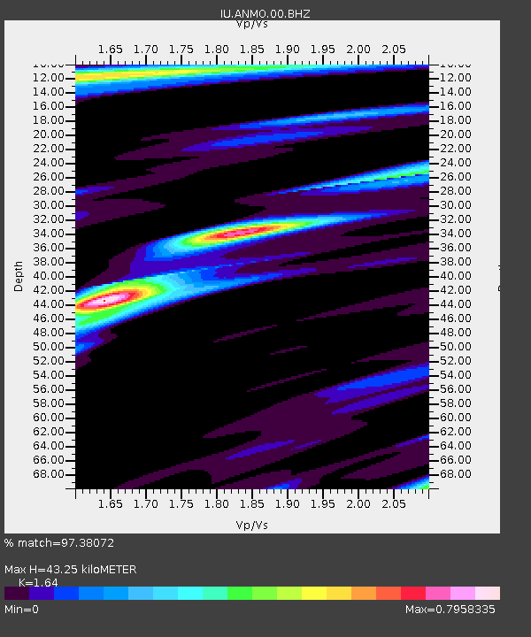
| Estimated Moho Depth: |
43.25 km |
| Estimated Crust Vp/Vs: |
1.64 |
| Assumed Crust Vp: |
6.502 km/s |
| Estimated Crust Vs: |
3.964 km/s |
| Estimated Crust Poisson's Ratio: |
0.20 |
|
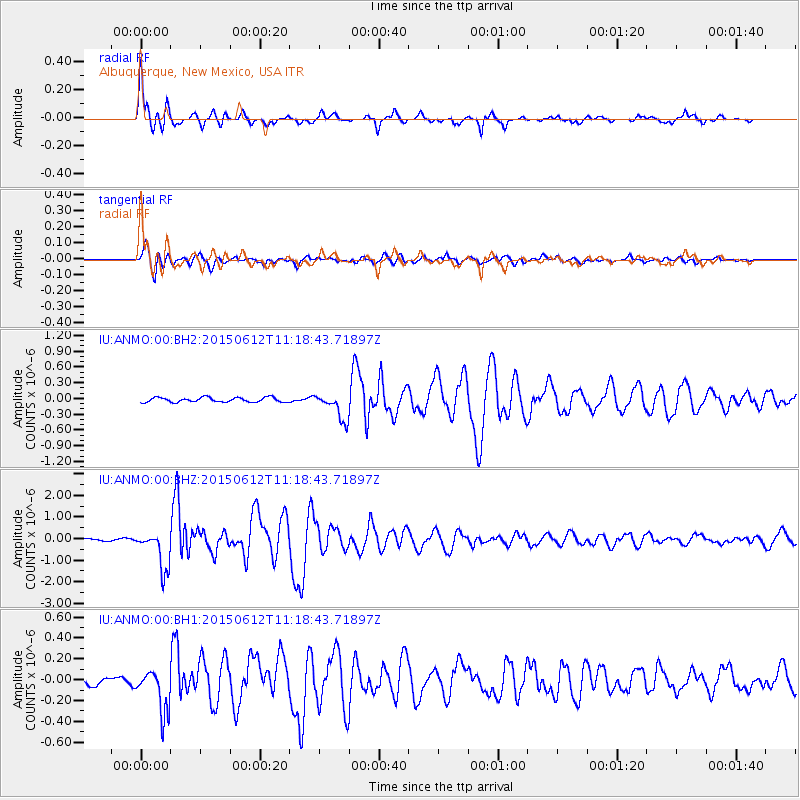
| Radial Match: |
97.38072 % |
| Radial Bump: |
329 |
| Transverse Match: |
92.059784 % |
| Transverse Bump: |
400 |
| SOD ConfigId: |
976571 |
| Insert Time: |
2015-06-26 12:28:11.549 +0000 |
| GWidth: |
2.5 |
| Max Bumps: |
400 |
| Tol: |
0.001 |
|
Signal To Noise
| Channel | StoN | STA | LTA |
| IU:ANMO:00:BHZ:20150612T11:18:43.71897Z | 22.66227 | 8.976288E-7 | 3.9608953E-8 |
| IU:ANMO:00:BH1:20150612T11:18:43.71897Z | 4.8025455 | 2.0451074E-7 | 4.258382E-8 |
| IU:ANMO:00:BH2:20150612T11:18:43.71897Z | 5.867953 | 2.543497E-7 | 4.334556E-8 |
| Arrivals |
| Ps | 4.4 SECOND |
| PpPs | 17 SECOND |
| PsPs/PpSs | 21 SECOND |


