You are here: Home > Network List > TA - USArray Transportable Network (new EarthScope stations) Stations List
> Station J26L Joseph Creek, AK, USA > Earthquake Result Viewer
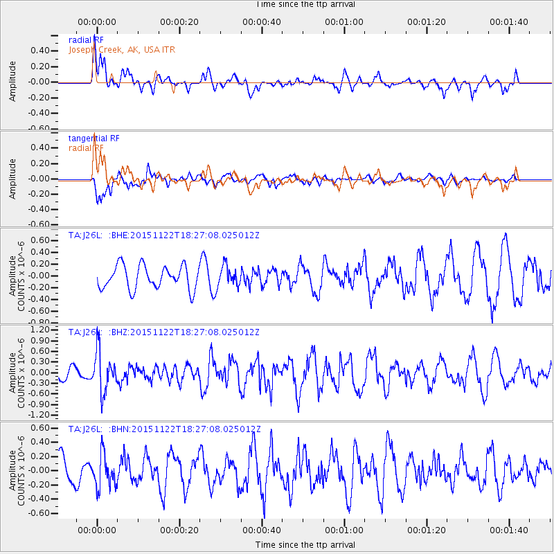
J26L Joseph Creek, AK, USA - Earthquake Result Viewer
*The percent match for this event was below the threshold and hence no stack was calculated.
| Earthquake location: |
Afghanistan-Tajikistan Bord Reg. |
| Earthquake latitude/longitude: |
36.5/71.5 |
| Earthquake time(UTC): |
2015/11/22 (326) 18:16:04 GMT |
| Earthquake Depth: |
92 km |
| Earthquake Magnitude: |
5.9 MB |
| Earthquake Catalog/Contributor: |
NEIC PDE/NEIC COMCAT |
|
| Network: |
TA USArray Transportable Network (new EarthScope stations) |
| Station: |
J26L Joseph Creek, AK, USA |
| Lat/Lon: |
64.50 N/143.56 W |
| Elevation: |
1144 m |
|
| Distance: |
75.6 deg |
| Az: |
14.859 deg |
| Baz: |
331.48 deg |
| Ray Param: |
$rayparam |
*The percent match for this event was below the threshold and hence was not used in the summary stack. |
|
| Radial Match: |
70.34728 % |
| Radial Bump: |
400 |
| Transverse Match: |
41.702873 % |
| Transverse Bump: |
400 |
| SOD ConfigId: |
7422571 |
| Insert Time: |
2019-04-21 10:41:47.798 +0000 |
| GWidth: |
2.5 |
| Max Bumps: |
400 |
| Tol: |
0.001 |
|
Signal To Noise
| Channel | StoN | STA | LTA |
| TA:J26L: :BHZ:20151122T18:27:08.025012Z | 3.9101546 | 5.7611123E-7 | 1.4733719E-7 |
| TA:J26L: :BHN:20151122T18:27:08.025012Z | 0.91516197 | 2.3475147E-7 | 2.5651357E-7 |
| TA:J26L: :BHE:20151122T18:27:08.025012Z | 0.7496769 | 1.5512846E-7 | 2.069271E-7 |
| Arrivals |
| Ps | |
| PpPs | |
| PsPs/PpSs | |


