You are here: Home > Network List > TA - USArray Transportable Network (new EarthScope stations) Stations List
> Station N31M Braeburn, Yukon, CA > Earthquake Result Viewer
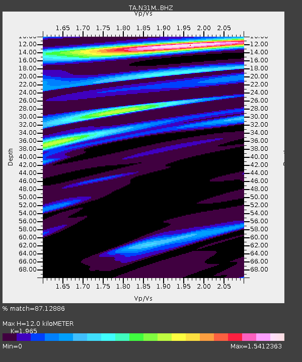
N31M Braeburn, Yukon, CA - Earthquake Result Viewer
| Earthquake location: |
Afghanistan-Tajikistan Bord Reg. |
| Earthquake latitude/longitude: |
36.5/71.5 |
| Earthquake time(UTC): |
2015/11/22 (326) 18:16:04 GMT |
| Earthquake Depth: |
92 km |
| Earthquake Magnitude: |
5.9 MB |
| Earthquake Catalog/Contributor: |
NEIC PDE/NEIC COMCAT |
|
| Network: |
TA USArray Transportable Network (new EarthScope stations) |
| Station: |
N31M Braeburn, Yukon, CA |
| Lat/Lon: |
61.49 N/135.78 W |
| Elevation: |
716 m |
|
| Distance: |
79.9 deg |
| Az: |
12.892 deg |
| Baz: |
337.993 deg |
| Ray Param: |
0.048451416 |
| Estimated Moho Depth: |
12.0 km |
| Estimated Crust Vp/Vs: |
1.97 |
| Assumed Crust Vp: |
6.419 km/s |
| Estimated Crust Vs: |
3.267 km/s |
| Estimated Crust Poisson's Ratio: |
0.33 |
|
| Radial Match: |
87.12886 % |
| Radial Bump: |
400 |
| Transverse Match: |
69.35519 % |
| Transverse Bump: |
400 |
| SOD ConfigId: |
7422571 |
| Insert Time: |
2019-04-21 10:41:58.067 +0000 |
| GWidth: |
2.5 |
| Max Bumps: |
400 |
| Tol: |
0.001 |
|

Signal To Noise
| Channel | StoN | STA | LTA |
| TA:N31M: :BHZ:20151122T18:27:31.475024Z | 1.9224011 | 1.0203441E-6 | 5.307655E-7 |
| TA:N31M: :BHN:20151122T18:27:31.475024Z | 0.93125725 | 5.1908836E-7 | 5.5740594E-7 |
| TA:N31M: :BHE:20151122T18:27:31.475024Z | 0.9633495 | 4.144938E-7 | 4.3026316E-7 |
| Arrivals |
| Ps | 1.9 SECOND |
| PpPs | 5.4 SECOND |
| PsPs/PpSs | 7.3 SECOND |


