You are here: Home > Network List > TA - USArray Transportable Network (new EarthScope stations) Stations List
> Station J20K Nowitna River, AK, USA > Earthquake Result Viewer
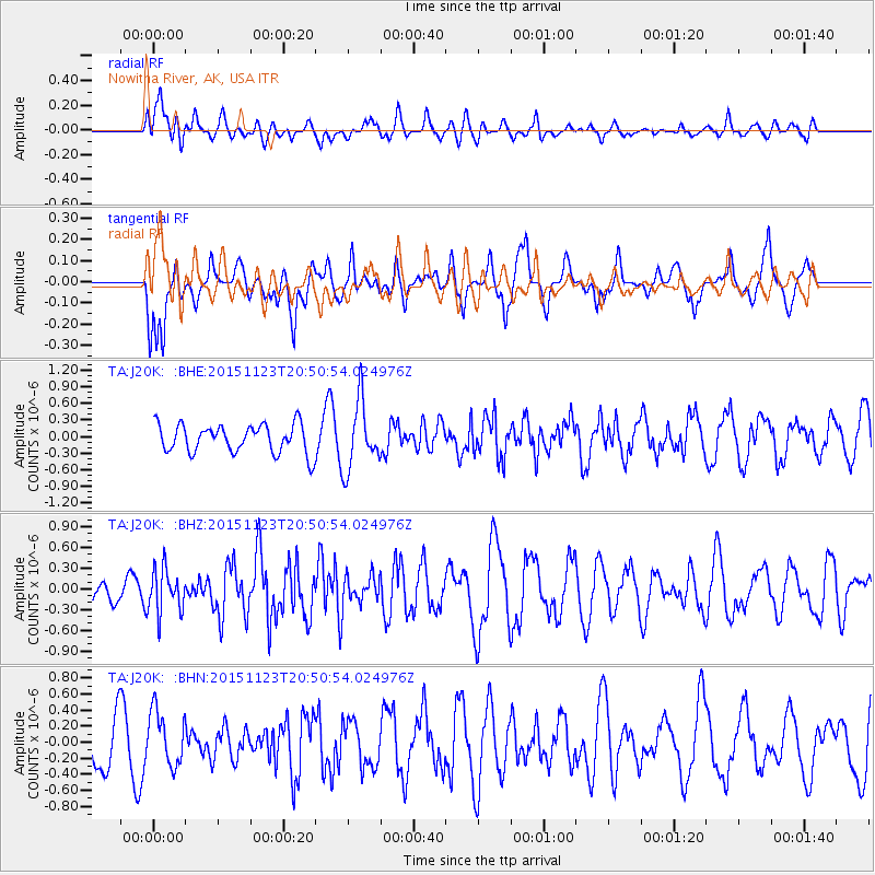
J20K Nowitna River, AK, USA - Earthquake Result Viewer
*The percent match for this event was below the threshold and hence no stack was calculated.
| Earthquake location: |
Guerrero, Mexico |
| Earthquake latitude/longitude: |
17.1/-98.8 |
| Earthquake time(UTC): |
2015/11/23 (327) 20:41:23 GMT |
| Earthquake Depth: |
38 km |
| Earthquake Magnitude: |
5.5 MB |
| Earthquake Catalog/Contributor: |
NEIC PDE/NEIC COMCAT |
|
| Network: |
TA USArray Transportable Network (new EarthScope stations) |
| Station: |
J20K Nowitna River, AK, USA |
| Lat/Lon: |
64.18 N/154.15 W |
| Elevation: |
314 m |
|
| Distance: |
59.9 deg |
| Az: |
335.402 deg |
| Baz: |
114.656 deg |
| Ray Param: |
$rayparam |
*The percent match for this event was below the threshold and hence was not used in the summary stack. |
|
| Radial Match: |
53.28274 % |
| Radial Bump: |
400 |
| Transverse Match: |
53.62844 % |
| Transverse Bump: |
400 |
| SOD ConfigId: |
7422571 |
| Insert Time: |
2019-04-21 10:47:53.029 +0000 |
| GWidth: |
2.5 |
| Max Bumps: |
400 |
| Tol: |
0.001 |
|
Signal To Noise
| Channel | StoN | STA | LTA |
| TA:J20K: :BHZ:20151123T20:50:54.024976Z | 1.2979339 | 3.1159783E-7 | 2.4007218E-7 |
| TA:J20K: :BHN:20151123T20:50:54.024976Z | 1.4253943 | 3.417864E-7 | 2.3978376E-7 |
| TA:J20K: :BHE:20151123T20:50:54.024976Z | 2.0922747 | 5.21351E-7 | 2.4917907E-7 |
| Arrivals |
| Ps | |
| PpPs | |
| PsPs/PpSs | |


