You are here: Home > Network List > TA - USArray Transportable Network (new EarthScope stations) Stations List
> Station MDND Maddock, ND, USA > Earthquake Result Viewer
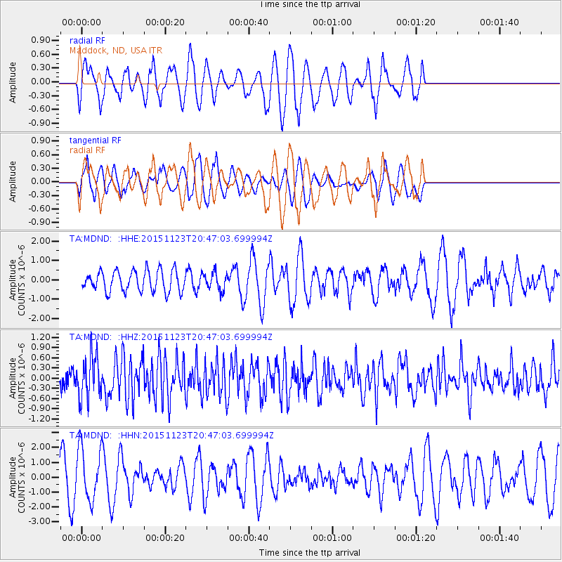
MDND Maddock, ND, USA - Earthquake Result Viewer
*The percent match for this event was below the threshold and hence no stack was calculated.
| Earthquake location: |
Guerrero, Mexico |
| Earthquake latitude/longitude: |
17.1/-98.8 |
| Earthquake time(UTC): |
2015/11/23 (327) 20:41:23 GMT |
| Earthquake Depth: |
38 km |
| Earthquake Magnitude: |
5.5 MB |
| Earthquake Catalog/Contributor: |
NEIC PDE/NEIC COMCAT |
|
| Network: |
TA USArray Transportable Network (new EarthScope stations) |
| Station: |
MDND Maddock, ND, USA |
| Lat/Lon: |
47.85 N/99.60 W |
| Elevation: |
479 m |
|
| Distance: |
30.7 deg |
| Az: |
358.971 deg |
| Baz: |
178.538 deg |
| Ray Param: |
$rayparam |
*The percent match for this event was below the threshold and hence was not used in the summary stack. |
|
| Radial Match: |
66.66442 % |
| Radial Bump: |
400 |
| Transverse Match: |
59.659 % |
| Transverse Bump: |
400 |
| SOD ConfigId: |
7422571 |
| Insert Time: |
2019-04-21 10:47:59.141 +0000 |
| GWidth: |
2.5 |
| Max Bumps: |
400 |
| Tol: |
0.001 |
|
Signal To Noise
| Channel | StoN | STA | LTA |
| TA:MDND: :HHZ:20151123T20:47:03.699994Z | 2.8799288 | 6.398176E-7 | 2.2216436E-7 |
| TA:MDND: :HHN:20151123T20:47:03.699994Z | 1.4635241 | 1.8343042E-6 | 1.2533475E-6 |
| TA:MDND: :HHE:20151123T20:47:03.699994Z | 0.8258731 | 4.442852E-7 | 5.379582E-7 |
| Arrivals |
| Ps | |
| PpPs | |
| PsPs/PpSs | |


