You are here: Home > Network List > US - United States National Seismic Network Stations List
> Station DGMT Dagmar, Montana, USA > Earthquake Result Viewer
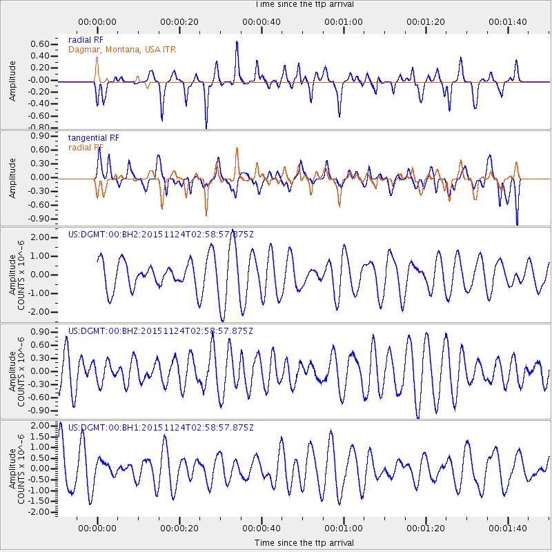
DGMT Dagmar, Montana, USA - Earthquake Result Viewer
*The percent match for this event was below the threshold and hence no stack was calculated.
| Earthquake location: |
South Of Tonga Islands |
| Earthquake latitude/longitude: |
-24.5/-173.8 |
| Earthquake time(UTC): |
2015/11/24 (328) 02:46:05 GMT |
| Earthquake Depth: |
15 km |
| Earthquake Magnitude: |
5.5 mwc |
| Earthquake Catalog/Contributor: |
NEIC PDE/ |
|
| Network: |
US United States National Seismic Network |
| Station: |
DGMT Dagmar, Montana, USA |
| Lat/Lon: |
48.47 N/104.20 W |
| Elevation: |
0.0 m |
|
| Distance: |
95.6 deg |
| Az: |
38.825 deg |
| Baz: |
239.079 deg |
| Ray Param: |
$rayparam |
*The percent match for this event was below the threshold and hence was not used in the summary stack. |
|
| Radial Match: |
34.77606 % |
| Radial Bump: |
294 |
| Transverse Match: |
37.043343 % |
| Transverse Bump: |
400 |
| SOD ConfigId: |
7422571 |
| Insert Time: |
2019-04-21 10:55:15.773 +0000 |
| GWidth: |
2.5 |
| Max Bumps: |
400 |
| Tol: |
0.001 |
|
Signal To Noise
| Channel | StoN | STA | LTA |
| US:DGMT:00:BHZ:20151124T02:58:57.875Z | 0.751058 | 2.2918441E-7 | 3.0514877E-7 |
| US:DGMT:00:BH1:20151124T02:58:57.875Z | 0.3948691 | 3.9045182E-7 | 9.888133E-7 |
| US:DGMT:00:BH2:20151124T02:58:57.875Z | 2.5004451 | 1.6846491E-6 | 6.737397E-7 |
| Arrivals |
| Ps | |
| PpPs | |
| PsPs/PpSs | |


