You are here: Home > Network List > CI - Caltech Regional Seismic Network Stations List
> Station GLA Glamis, Glamis, CA, USA > Earthquake Result Viewer
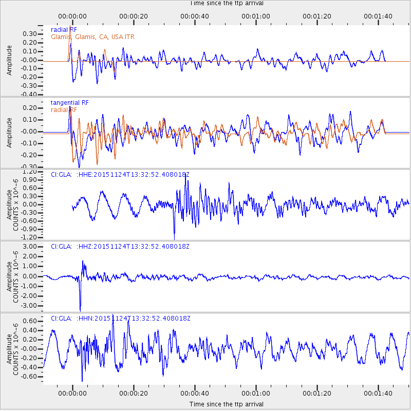
GLA Glamis, Glamis, CA, USA - Earthquake Result Viewer
*The percent match for this event was below the threshold and hence no stack was calculated.
| Earthquake location: |
Mariana Islands |
| Earthquake latitude/longitude: |
18.8/145.3 |
| Earthquake time(UTC): |
2015/11/24 (328) 13:21:36 GMT |
| Earthquake Depth: |
586 km |
| Earthquake Magnitude: |
5.9 MWB |
| Earthquake Catalog/Contributor: |
NEIC PDE/NEIC COMCAT |
|
| Network: |
CI Caltech Regional Seismic Network |
| Station: |
GLA Glamis, Glamis, CA, USA |
| Lat/Lon: |
33.05 N/114.83 W |
| Elevation: |
610 m |
|
| Distance: |
87.9 deg |
| Az: |
55.893 deg |
| Baz: |
290.923 deg |
| Ray Param: |
$rayparam |
*The percent match for this event was below the threshold and hence was not used in the summary stack. |
|
| Radial Match: |
51.966297 % |
| Radial Bump: |
400 |
| Transverse Match: |
36.836998 % |
| Transverse Bump: |
400 |
| SOD ConfigId: |
7422571 |
| Insert Time: |
2019-04-21 11:07:30.472 +0000 |
| GWidth: |
2.5 |
| Max Bumps: |
400 |
| Tol: |
0.001 |
|
Signal To Noise
| Channel | StoN | STA | LTA |
| CI:GLA: :HHZ:20151124T13:32:52.408018Z | 6.4272704 | 9.228501E-7 | 1.4358352E-7 |
| CI:GLA: :HHN:20151124T13:32:52.408018Z | 0.7718801 | 2.0942977E-7 | 2.7132424E-7 |
| CI:GLA: :HHE:20151124T13:32:52.408018Z | 1.1210614 | 3.2150484E-7 | 2.8678608E-7 |
| Arrivals |
| Ps | |
| PpPs | |
| PsPs/PpSs | |


